Metro Route 85
|
Pictures are arranged from east to west. Click here to show the route.
| Route 85 ends at Route 52 (Main Street). Click here for Route 52 images. | ||||
| Location | Description | Photo
| ||
| City of Winnipeg |
Westbound view at Main Street.  Photograph taken in February 2010. |
 |
||
| City of Winnipeg |
A look at the plaque on the sidewalk at the corner of Portage Avenue and Main Stret commemorating the beginning of Portage Avenue.  Photograph taken in April 2010. |
 |
||
| City of Winnipeg |
Westbound view showing the first westbound markers for both Route 85 and the Yellowhead Highway. The directional sign for the Yellowhead Highway read “Mile 0” until its disappearance.  Photograph taken in April 2010. |
 |
||
| City of Winnipeg |
Westbound view showing a closeup of the first westbound markers for both Route 85 and the Yellowhead Highway.  Photograph taken in April 2010. |
 |
||
| Route 85 meets Route 57 at Notre Dame Avenue and Donald Street. Click here for Route 57 images. | ||||
| City of Winnipeg |
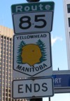
Eastbound view showing the marker indicating the end of both Route 85 and the Yellowhead Highway.  Photograph taken in January 2010. |
 |
||
| City of Winnipeg |
Eastbound view showing a closeup of the marker indicating the end of both Route 85 and the Yellowhead Highway.  Photograph taken in January 2010. |
 |
||
| Route 85 meets Route 42 at Donald and Smith Streets. Click here for Route 42 images. | ||||
| City of Winnipeg |
Eastbound view at Carlton Street.  Photograph taken in December 2009. |
 |
||
| City of Winnipeg |
Westbound view at Vaughan Street.  Photograph taken in September 2009. |
 |
||
| City of Winnipeg |
Westbound view at Kennedy Street.  Photograph taken in June 2011. |
 |
||
| Route 85 meets Route 62 at Colony Street/Memorial Boulevard. Click here for Route 62 images. | ||||
| City of Winnipeg |
Eastbound view approaching Furby Street.  Photograph taken in January 2013. |
 |
||
| Route 85 meets Route 70 at Sherbrook and Maryland Streets. Click here for Route 70 images. | ||||
| City of Winnipeg |
Westbound view approaching McGee Street showing the markers for Route 85 and the Yellowhead Highway.  Photograph taken in March 2011. |
 |
||
| City of Winnipeg |
Eastbound view approaching Victor Street showing the first markers without the PTH 1 signage. At right is the site of the former Midway Chrysler dealership that was slated for a Canada Post depot. After much controversy and whining on the part of the students at nearby Gordon Bell High School and renegade MP Pat Martin, the provincial government purchased the lot for a greenspace.  Photograph taken in January 2013. |
 |
||
| City of Winnipeg |
Eastbound view approaching Victor Street showing a closeup of the first markers without the PTH 1 signage.  Photograph taken in January 2013. |
 |
||
| Route 85 follows |
||||
© Curtis Walker. All rights reserved. All pictures used on this site are the property of the respective photographers and are used by permission. No picture may be used without the consent of the respective photographer.
All pictures taken by Curtis Walker unless otherwise noted.