 |
|
Pictures are arranged from east to west. Click here to show the route.
;)
| Route 105 ends at PTH 75/Route 42. Click here for PTH 75 images and here for Route 42 images. | ||||
| Location | Description | Photo
| ||
| City of Winnipeg |
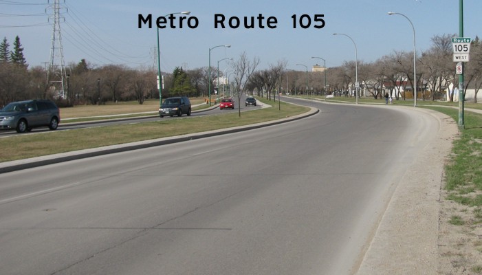
Westbound view on Grant Avenue showing the first westbound marker.  Photograph taken in April 2010. |
;) |
||
| City of Winnipeg |
Eastbound view on Grant Avenue approaching Pembina Highway. Photograph taken in April 2010. |
;) |
||
| City of Winnipeg |
Eastbound view on Grant Avenue past Stafford Street. Photograph taken in November 2009. |
;) |
||
| Route 105 meets Route 70 at Stafford Street. Click here for Route 70 images. | ||||
| City of Winnipeg |
Westbound view on Grant Avenue past Stafford Street showing the newly installed marker featuring Clearview numbering. Photograph taken in May 2012. |
|||
| City of Winnipeg |
Westbound view on Grant Avenue past Stafford Street. Photograph taken in November 2009. |
;) |
||
| City of Winnipeg |
Westbound view on Grant Avenue near Rockwood Street. Photograph taken in November 2009. |
;) |
||
| City of Winnipeg |
Westbound view on Grant Avenue past Nathaniel Street. Photograph taken in November 2009. |
;) |
||
| City of Winnipeg |
Westbound view on Grant Avenue approaching Waverley Street. Photograph taken in November 2009. |
;) |
||
| Route 105 meets Route 80 at Waverley Street. Click here for Route 80 images. | ||||
| City of Winnipeg |
Westbound view on Grant Avenue past Queenston Street. Photograph taken in July 2009. |
;) |
||
| City of Winnipeg |
Westbound view on Grant Avenue at Campbell Street. Photograph taken in November 2009. |
;) |
||
| Route 105 meets Route 90 at Kenaston Boulevard. Click here for Route 90 images. | ||||
| City of Winnipeg |
Westbound view on Grant Avenue past Kenaston Boulevard. Photograph taken in November 2009. |
;) |
||
| City of Winnipeg |
Westbound view on Grant Avenue at Egeland Boulevard. Photograph taken in January 2013. |
;) |
||
| City of Winnipeg |
Westbound view on Grant Avenue approaching Park Boulevard East. Photograph taken in July 2009. |
;) |
||
| City of Winnipeg |
Westbound view on Grant Avenue at Park Boulevard East. Photograph taken in January 2013. |
;) |
||
| Route 105 meets Route 96 at Shaftesbury Boulevard. Click here for Route 96 images. | ||||
| City of Winnipeg |
Westbound view on Grant Avenue at Shaftesbury Boulevard showing the new overhead walkway being constructed to connect the two halves of the Canadian Mennonite University campus. Photograph taken in May 2014. |
;) |
||
| City of Winnipeg |
Westbound view on Grant Avenue past Shaftesbury Boulevard showing the pair of markers. Photograph taken in January 2013. |
;) |
||
| City of Winnipeg |
Eastbound view on Grant Avenue at Shaftesbury Boulevard. Photograph taken in April 2009. |
;) |
||
| City of Winnipeg |
Westbound view on Grant Avenue past Shaftesbury Boulevard. Photograph taken in November 2009. |
;) |
||
| City of Winnipeg |
Eastbound view on Grant Avenue passing through Assiniboine Forest. Photograph taken in January 2013. |
;) |
||
| City of Winnipeg |
Westbound view on Grant Avenue at Cathcart Street. Photograph taken in April 2009. |
;) |
||
| City of Winnipeg |
Westbound view on Grant Avenue approaching Haney Street. Photograph taken in November 2009. |
;) |
||
| City of Winnipeg |
Eastbound view on Grant Avenue past William R. Clement Parkway showing the pair of newly installed markers featuring Clearview numbering. Photograph taken in January 2013. |
;) |
||
| Route 105 meets Route 96 at William R. Clement Parkway. Click here for Route 96 images. | ||||
| City of Winnipeg |
Westbound view on Grant Avenue approaching Oakdale Drive. Photograph taken in October 2009. |
;) |
||
| City of Winnipeg |
Eastbound view on Grant Avenue at Oakdale Drive. Photograph taken in January 2013. |
;) |
||
| City of Winnipeg |
Westbound view on Grant Avenue approaching the intersection of Roblin Boulevard and Roblin Boulevard. Grant Avenue continues west as Roblin Boulevard and the turnoff is for Route 95, which is also Roblin Boulevard. Welcome to Winnipeg. Photograph taken in June 2009. |
;) |
||
| Route 105 meets Route 95 at Roblin Boulevard. Click here for Route 95 images. | ||||
| City of Winnipeg |
Westbound view on Grant Avenue at Denton Place. Photograph taken in January 2013. |
;) |
||
| City of Winnipeg |
Westbound view on Roblin Boulevard at Willow Ridge Road. Photograph taken in May 2009. |
;) |
||
| City of Winnipeg |
Westbound view on Roblin Boulevard past Dale Boulevard showing the sign indicating the upcoming end of Route 105. Photograph taken in September 2009. |
;) |
||
| Route 105 ends at PTH 100 and continues west as PR 241. Click here for PTH 100 images and here for PR 241 images. | ||||
© Curtis Walker. All rights reserved. All pictures used on this site are the property of the respective photographers and are used by permission. No picture may be used without the consent of the respective photographer.
All pictures taken by Curtis Walker unless otherwise noted.