|
;)
Pictures are arranged from east to west.
| PR 241 ends at |
||||
| Location | Description | Photo
| ||
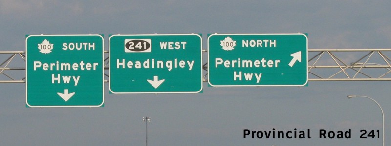
| City of Winnipeg |
Westbound view approaching the junction of PTH 100. The smoke in the picture is from the local farmers burning stubble.  Photograph taken in October 2007. |
;) |
||
| City of Winnipeg |
Westbound view showing the new advisory sign for the 511 traveler information service. Photograph taken in February 2012. |
;) |
||
| City of Winnipeg |
A view of the sign for PR 241 from the exit off northbound PTH 100. Photograph taken in September 2009. |
;) |
||
| City of Winnipeg |
Westbound view on the overpass crossing PTH 100. The smoke in the picture is from the local farmers burning stubble. Photograph taken in October 2007. |
;) |
||
| City of Winnipeg |
Westbound view on the overpass crossing PTH 100. The smoke in the picture is from the local farmers burning stubble. Photograph taken in October 2007. |
;) |
||
| City of Winnipeg |
Westbound view at the turnoff for PTH 100 east. Photograph taken in April 2011. |
;) |
||
| City of Winnipeg |
Eastbound view at the junction of PTH 100. Photograph taken in January 2009. |
;) |
||
| RM of Headingley |
Westbound view showing the sign indicating entry into the RM of Headingley. Photograph taken in May 2014. |
;) |
||
| RM of Headingley |
Westbound view showing the Adopt-A-Highway sign. Photograph taken in May 2014. |
;) |
||
| RM of Headingley |
Westbound view showing the sign welcoming visitors to Headingley. Photograph taken in May 2014. |
;) |
||
| RM of Headingley |
Westbound view just west of the junction of PTH 100 showing the first westbound reassurance marker for PR 241. Photograph taken in July 2005. |
;) |
||
| RM of Headingley |
Westbound view showing the sign giving the distance to Headingley. Photograph taken in November 2009. |
;) |
||
| RM of Headingley |
Westbound view showing the sign for the Assiniboine Landing housing development. Photograph taken in May 2009. |
;) |
||
| RM of Headingley |
Eastbound view 2 km from the junction of PTH 100. Photograph taken in January 2009. |
;) |
||
| RM of Headingley |
Eastbound view between PR 334 and PTH 100. Photograph taken in June 2003. |
;) |
||
| RM of Headingley |
Westbound view approaching the eastern junction of PR 334. Photograph taken in September 2009. |
;) |
||
| RM of Headingley |
Westbound view approaching the junction of PR 334 showing the same view of the above shot with some scenic hoarfrost. Photograph taken in March 2010. |
;) |
||
| RM of Headingley |
Westbound view approaching the junction of PR 334. Photograph taken in March 2005. |
;) |
||
| RM of Headingley |
Eastbound view between PR 334 and PTH 100. Photograph taken in June 2003. |
;) |
||
| RM of Headingley |
Westbound view approaching Charles Glen Drive. Photograph taken in June 2011. |
;) |
||
| RM of Headingley |
Westbound view showing the advance signage for the junction of PR 334. This new signage was installed a month after the decommissioning of the former western half of PR 241 and the subsequent rerouting of PR 334. Photograph taken in July 2013. |
;) |
||
| RM of Headingley |
Westbound view near the junction of PR 334. Photograph taken in September 2009. |
;) |
||
| RM of Headingley |
Westbound view approaching the junction of PR 334 showing the newly installed markers indicating the end of PR 241. Photograph taken in June 2013. |
;) |
||
| RM of Headingley |
Eastbound view showing the newly installed marker featuring the “warthog”-style buffalo and Clearview numbering. As of June 2013, this is now the first and only eastbound reassurance marker. Photograph taken in June 2013. |
;) |
||
| PR 241 ends at PR 334/Harris Road in Headingley. Click here for PR 334 images. | ||||
| The section of PR 241 between the Taylor Bridge and PR 424 was decommissioned in June 2013. | ||||
| RM of Headingley |
Westbound view showing the first reassurance marker west of the junction of PR 334. Photograph taken in January 2009. |
;) |
||
| RM of Headingley |
Eastbound view approaching the junction of PR 334. Photograph taken in January 2010. |
;) |
||
| RM of Headingley |
Westbound view at Alboro Street. At right is the snow-covered Assiniboine River. Photograph taken in February 2009. |
;) |
||
| RM of Headingley |
Westbound view approaching the newly installed stop sign at Alboro Street. Photograph taken in May 2013. |
;) |
||
| RM of Headingley |
Westbound view west of Alboro Street showing the sign that says that cycling side-by-side is prohibited. Photograph taken in February 2009. |
;) |
||
| RM of Headingley |
Eastbound view showing the advance signage for the junction of PR 334. Photograph taken in January 2010. |
;) |
||
| RM of Headingley |
Westbound view at Rodney Street. Photograph taken in November 2012. |
;) |
||
| RM of Headingley |
Westbound view west of Wescana Street. Photograph taken in February 2009. |
;) |
||
| RM of Headingley |
Westbound view nearing the end of the pavement. The road continues west with a hard, bumpy surface and loose gravel. Photograph taken in February 2009. |
;) |
||
| RM of Headingley |
Eastbound view nearing the end of the gravel surface. The road ahead is paved through Headingley and into Winnipeg. Photograph taken in March 2010. |
;) |
||
| RM of Headingley |
Westbound view entering the RM of Cartier. Photograph taken in February 2009. |
;) |
||
| RM of Cartier |
Westbound view showing the sign for Beaudry Provincial Park. The park entrance is located about a half mile ahead. Photograph taken in March 2010. |
;) |
||
| RM of Cartier |
Westbound view approaching a creek east of the entrance to Beaudry Provincial Park. Photograph taken in February 2009. |
;) |
||
| RM of Cartier |
Westbound view approaching the entrance to Beaudry Provincial Park. Photograph taken in May 2009. |
;) |
||
| RM of Cartier |
The sign for Beaudry Provincial Park. Photograph taken in May 2009. |
;) |
||
| RM of Cartier |
Westbound view west of the entrance to Beaudry Provincial Park. Photograph taken in December 2006. |
;) |
||
| RM of Cartier |
Westbound view approaching Lido Plage Road. Photograph taken in February 2009. |
;) |
||
| RM of Cartier |
Westbound view showing the sign for Camp Assiniboia, a nearby Bible camp. Photograph taken in May 2009. |
;) |
||
| RM of Cartier |
Westbound view at Lido Plage Road. Both Google Maps and Virtual Earth show PR 241 proceeding north on Lido Plage Road, when, in fact, it turns south and ends at PR 424. Photograph taken in February 2009. |
;) |
||
| RM of Cartier |
Southbound view from Lido Plage Road showing the erroneous signs for the approaching PR 241 and PR 424. PR 241 proceeds eastbound at Roblin Boulevard as indicated, but it continues westbound for a short distance ahead along Lido Plage Road where it reaches PR 424, a route that does not follow Lido Plage Road at all, despite the signage to the contrary. Photograph taken in May 2009. |
;) |
||
| RM of Cartier |
Westbound view on Lido Plage Road approaching PR 424. Photograph taken in February 2009. |
;) |
||
| RM of Cartier |
Westbound view at the former western terminus of PR 241, the junction of PR 424. Photograph taken in July 2006. |
;) |
||
| PR 241 formerly ended at PR 424 in the RM of Cartier. Click here for PR 424 images. | ||||
© Curtis Walker. All rights reserved. All pictures used on this site are the property of the respective photographers and are used by permission. No picture may be used without the consent of the respective photographer.
All pictures taken by Curtis Walker unless otherwise noted.