|
Southern Terminus: Junction of R-204 in Saint-Georges.
Northern Terminus: Kilometer marker 182 in Stoneham-et-Tewkesbury. Click here to show the route. |
;)
Pictures are arranged from south to north.
| Location | Description | Photo
| ||
| Ville de Lévis |
A look at the trailblazer signage at Rue du Parc-des-Chutes.  Photograph taken in June 2023. |
;) |
||
| Ville de Lévis |
Westbound view on Rue du Parc-des-Chutes showing the trailblazer signage for the A-73 south on-ramp. Photograph taken in June 2023. |
;) |
||
| Ville de Lévis |
Northbound view from atop the overpass at Rue du Parc-des-Chutes. Photograph taken in June 2023. |
;) |
||
| Ville de Lévis |
Westbound view coming from westbound A-20. Photograph taken in June 2023. |
;) |
||
| Ville de Lévis |
Southbound view at the A-20 west exit. Photograph taken in July 2019. |
;) |
||
| Ville de Lévis |
Southbound view at the A-20 west exit. Photograph taken in July 2019. |
;) |
||
| Ville de Lévis |
Northbound view coming from westbound A-20. Photograph taken in June 2023. |
;) |
||
| Ville de Lévis |
Northbound view coming from eastbound A-20. Photograph taken in July 2019. |
;) |
||
| Ville de Lévis |
Northbound view coming from eastbound A-20. Photograph taken in June 2023. |
;) |
||
| Ville de Lévis |
Southbound view approaching the A-20 west exit. Photograph taken in July 2019. |
;) |
||
| Ville de Lévis |
Southbound view at the A-20 east exit. Photograph taken in June 2023. |
;) |
||
| Ville de Lévis |
Northbound view showing the 2 km advance signage for the Boulevard Champlain/Avenue des Hôtels exit. Photograph taken in July 2019. |
;) |
||
| Ville de Lévis |
Northbound view showing the 2 km advance signage for the R-136 exit. Photograph taken in June 2023. |
;) |
||
| Ville de Lévis |
Southbound view at the A-20 east exit. Photograph taken in July 2019. |
;) |
||
| Ville de Lévis |
Southbound view approaching the Rue du Parc-des-Chutes exit. Photograph taken in June 2023. |
;) |
||
| Ville de Lévis |
Northbound view crossing the Rivière Chaudière. Photograph taken in July 2019. |
;) |
||
| Ville de Lévis |
Northbound view showing the 3 km advance signage for the A-540 exit. Photograph taken in June 2023. |
;) |
||
| Ville de Lévis |
Southbound view crossing the Rivière Chaudière showing the advance signage for the A-20 exits. Photograph taken in June 2023. |
;) |
||
| Ville de Lévis |
Southbound view approaching the A-20 interchange. Photograph taken in July 2019. |
;) |
||
| Ville de Lévis |
Northbound view approaching the Pont Pierre-Laporte. Photograph taken in July 2019. |
;) |
||
| Ville de Lévis |
Southbound view approaching the A-20 interchange. Photograph taken in July 2019. |
;) |
||
| Ville de Lévis |
Southbound view approaching the A-20 interchange. Photograph taken in July 2019. |
;) |
||
| Ville de Lévis |
Northbound view approaching the Pont Pierre-Laporte. Photograph taken in July 2019. |
;) |
||
| Ville de Lévis |
Northbound view approaching the Pont Pierre-Laporte. Photograph taken in July 2019. |
;) |
||
| Ville de Lévis |
Northbound view crossing the Pont Pierre-Laporte. Photograph taken in June 2023. |
;) |
||
| Ville de Lévis |
Southbound view crossing the Pont Pierre-Laporte. Photograph taken in July 2019. |
;) |
||
| Ville de Lévis |
Northbound view crossing the Pont Pierre-Laporte. Photograph taken in July 2019. |
;) |
||
| Ville de Lévis |
Southbound view crossing the Pont Pierre-Laporte. Photograph taken in July 2019. |
;) |
||
| Ville de Lévis |
Northbound view crossing the Pont Pierre-Laporte. Photograph taken in July 2019. |
;) |
||
| Ville de Lévis |
Northbound view crossing the Pont Pierre-Laporte. Photograph taken in July 2019. |
;) |
||
| Ville de Lévis |
Southbound view crossing the Pont Pierre-Laporte. Photograph taken in July 2019. |
;) |
||
| Ville de Lévis |
Northbound view crossing the Pont Pierre-Laporte. Photograph taken in July 2019. |
;) |
||
| Ville de Lévis |
Southbound view crossing the Pont Pierre-Laporte. Photograph taken in July 2019. |
;) |
||
| Ville de Lévis |
Northbound view crossing the Pont Pierre-Laporte. Photograph taken in June 2023. |
;) |
||
| Ville de Lévis |
Northbound view crossing the Pont Pierre-Laporte. Photograph taken in July 2019. |
;) |
||
| Ville de Lévis |
Southbound view crossing the Pont Pierre-Laporte. Photograph taken in June 2023. |
;) |
||
| Ville de Québec |
Southbound view crossing the Pont Pierre-Laporte. Photograph taken in July 2019. |
;) |
||
| Ville de Québec |
Northbound view crossing the Pont Pierre-Laporte. Photograph taken in July 2019. |
;) |
||
| Ville de Québec |
Northbound view crossing the Pont Pierre-Laporte. Photograph taken in June 2023. |
;) |
||
| Ville de Québec |
Northbound view approaching the R-136 exit. Photograph taken in July 2019. |
;) |
||
| Ville de Québec |
Southbound view crossing the Pont Pierre-Laporte. Photograph taken in July 2019. |
;) |
||
| Ville de Québec |
Southbound view crossing the Pont Pierre-Laporte. Photograph taken in July 2019. |
;) |
||
| Ville de Québec |
Northbound view approaching the R-136 exit. Photograph taken in July 2019. |
;) |
||
| Ville de Québec |
Northbound view approaching the R-136 exit. Photograph taken in July 2019. |
;) |
||
| Ville de Québec |
Northbound view at the R-136 exit. Photograph taken in July 2019. |
;) |
||
| Ville de Québec |
Northbound view at the R-136 exit. Photograph taken in June 2023. |
;) |
||
| Ville de Québec |
Southbound view crossing the Pont Pierre-Laporte. Photograph taken in July 2019. |
;) |
||
| Ville de Québec |
Northbound view showing the sign indicating entry into Québec (Sainte-Foy). Photograph taken in June 2023. |
');) |
||
| Ville de Québec |
Southbound view passing the R-136 exit. Photograph taken in July 2019. |
;) |
||
| Ville de Québec |
Southbound view passing the R-136 exit. Photograph taken in July 2019. |
;) |
||
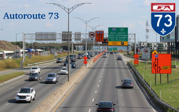
| Ville de Québec |
Northbound view approaching the Chemin St-Louis exit showing the advance signage for the A-540 and R-175 exits. Photograph taken in July 2019. |
;) |
||
| Ville de Québec |
Northbound view approaching the Chemin St-Louis exit. Photograph taken in July 2019. |
;) |
||
| Ville de Québec |
Southbound view at the R-136 exit. Photograph taken in July 2019. |
;) |
||
| Ville de Québec |
Southbound view approaching the R-136 exit, the last before the bridge. Photograph taken in July 2019. |
;) |
||
| Ville de Québec |
Northbound view approaching the Chemin St-Louis exit. Photograph taken in July 2019. |
;) |
||
| Ville de Québec |
Southbound view approaching the R-136 exit. Photograph taken in June 2023. |
;) |
||
| Ville de Québec |
Northbound view approaching the Chemin St-Louis exit. Photograph taken in July 2019. |
;) |
||
| Ville de Québec |
Northbound view at the Chemin St-Louis exit. Photograph taken in June 2023. |
;) |
||
| Ville de Québec |
Westbound view on Chemin St-Louis showing the trailblazer signage for A-73. Photograph taken in June 2023. |
;) |
||
| Ville de Québec |
Southbound view passing under Chemin St-Louis. Photograph taken in July 2019. |
;) |
||
| Ville de Québec |
Northbound view passing the Chemin St-Louis exit approaching the R-175 and A-540 exits. Photograph taken in July 2019. |
;) |
||
| Ville de Québec |
Southbound view showing the 400 m advance signage for the R-136 exit. Photograph taken in July 2019. |
;) |
||
| Ville de Québec |
Southbound view showing the 400 m advance signage for the R-136 exit. Photograph taken in June 2023. |
;) |
||
| Ville de Québec |
Southbound view past the R-175/Boulevard Laurier exit. Photograph taken in July 2019. |
;) |
||
| Ville de Québec |
Southbound view approaching the R-136 exit. Photograph taken in June 2023. |
;) |
||
| Ville de Québec |
Northbound view at the R-175/Boulevard Laurier exit. Photograph taken in July 2019. |
;) |
||
| Ville de Québec |
Southbound view from atop the overpass at Boulevard Hochelaga showing the overhead signage for the A-540/R-175 exits. Photograph taken in July 2019. |
;) |
||
| Ville de Québec |
Eastbound view on Boulevard Hochelaga approaching Route de l'Église showing the detour trailblazer signage for A-73 south. Photograph taken in July 2019. |
;) |
||
| Ville de Québec |
Westbound view on Boulevard Hochelaga approaching Avenue Lavigerie showing the detour trailblazer signage for A-73 south. Photograph taken in July 2019. |
;) |
||
| Ville de Québec |
Eastbound view on Boulevard Hochelaga approaching Avenue de Rochebelle showing the trailblazer signage for A-73 north. Photograph taken in July 2019. |
;) |
||
| Ville de Québec |
A look at the back of the above sign showing its weight in kilograms, a detail people at MTQ seem to think is vitally important. Photograph taken in July 2019. |
;) |
||
| Ville de Québec |
Westbound view on Boulevard Hochelaga at Avenue de Rochebelle showing the trailblazer signage for the A-73 on-ramps. Photograph taken in July 2019. |
;) |
||
| Ville de Québec |
Northbound view on Avenue de Rochebelle showing the trailblazer signage for A-73 north. Photograph taken in July 2019. |
;) |
||
| Ville de Québec |
Northbound view atop the overpass at Boulevard Hochelaga. Photograph taken in July 2019. |
;) |
||
| Ville de Québec |
Southbound view from the pedestrian overpass south of Chemin des Quatre-Bourgeois. In the distance are the Québec and Pierre Laporte Bridges. Photograph taken in July 2019. |
;) |
||
| Ville de Québec |
Northbound view from the pedestrian overpass south of Chemin des Quatre-Bourgeois. Photograph taken in July 2019. |
;) |
||
| Ville de Québec |
Southbound view from atop the overpass at Chemin des Quatre-Bourgeois. At left is a popular layover point for RTC buses on adjacent Avenue de Rochebelle. Photograph taken in July 2019. |
;) |
||
| Ville de Québec |
Eastbound view on Chemin des Quatre-Bourgeois showing the trailblazer signage for A-73 north. Photograph taken in July 2019. |
;) |
||
| Ville de Québec |
Westbound view on Chemin des Quatre-Bourgeois showing the trailblazer signage for A-73 south. Photograph taken in July 2019. |
;) |
||
| Ville de Québec |
Eastbound view on Chemin des Quatre-Bourgeois showing the trailblazer signage for the A-73 on-ramps. Photograph taken in July 2019. |
;) |
||
| Ville de Québec |
Northbound view from atop the overpass at Chemin des Quatre-Bourgeois. Photograph taken in July 2019. |
;) |
||
| Ville de Québec |
Eastbound view on Chemin des Quatre-Bourgeois approaching Avenue de Bourgogne showing the trailblazer signage for A-540 north. Photograph taken in July 2019. |
;) |
||
© Curtis Walker. All rights reserved. All pictures used on this site are the property of the respective photographers and are used by permission. No picture may be used without the consent of the respective photographer.
All pictures taken by Curtis Walker unless otherwise noted.