|
Southern Terminus: Junction of R-218 in Saint-Lambert-de-Lauzon.
Northern Terminus: Junction of R-172 in Saguenay. Click here to show the route. |
;)
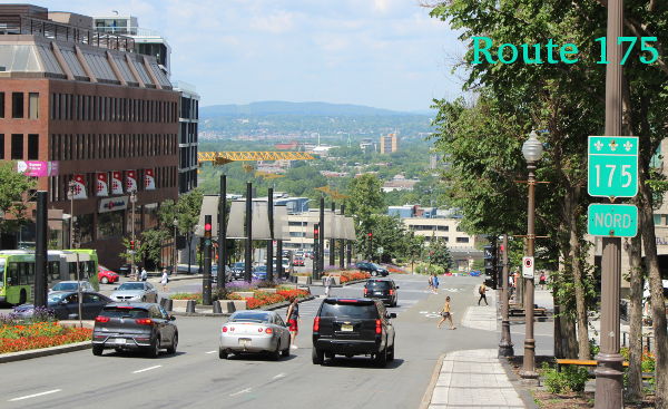
Pictures are arranged from south to north.
| Location | Description | Photo
| ||
| Ville de Québec |
Southbound view crossing the bridge.  Photograph taken in June 2023. |
;) |
||
| Ville de Québec |
A look at the reference marker at the foot of the bridge. Photograph taken in June 2023. |
;) |
||
| Ville de Québec |
Southbound view crossing the bridge. Photograph taken in June 2023. |
;) |
||
| Ville de Québec |
Northbound view approaching the R-136 exit. Photograph taken in June 2023. |
;) |
||
| Ville de Québec |
Northbound view approaching the R-136 exit. Photograph taken in June 2023. |
;) |
||
| Ville de Québec |
Northbound view at the R-136 exit. Photograph taken in June 2023. |
;) |
||
| Ville de Québec |
A look at the Pont de Québec from the observation deck at the quai des Cageux. Photograph taken in July 2019. |
;) |
||
| Ville de Québec |
Westbound view approaching the A-73/A-540 interchange. Photograph taken in July 2019. |
;) |
||
| Ville de Québec |
Westbound view approaching the A-73/A-540 interchange. Photograph taken in June 2023. |
;) |
||
| Ville de Québec |
Eastbound view on Boulevard Laurier past A-73. Photograph taken in July 2019. |
;) |
||
| Ville de Québec |
Eastbound view on Boulevard Laurier approaching Avenue Lavigerie. Photograph taken in July 2019. |
;) |
||
| Ville de Québec |
Westbound view on Boulevard Laurier past Avenue Lavigerie. Photograph taken in July 2019. |
;) |
||
| Ville de Québec |
Southbound view on Avenue Lavigerie showing the markers at Boulevard Laurier. Photograph taken in July 2019. |
;) |
||
| Ville de Québec |
Eastbound view on Boulevard Laurier past Avenue Lavigerie. Photograph taken in July 2019. |
;) |
||
| Ville de Québec |
Eastbound view on Boulevard Laurier showing the sign indicating entry into the Ville de Québec. Photograph taken in July 2019. |
;) |
||
| Ville de Québec |
Eastbound view on Boulevard Laurier showing the marker past Avenue Lavigerie. Photograph taken in July 2019. |
;) |
||
| Ville de Québec |
Westbound view on Boulevard Laurier approaching Avenue Lavigerie. Photograph taken in July 2019. |
;) |
||
| Ville de Québec |
Eastbound view on Boulevard Laurier passing the Hôtel Classique. Photograph taken in July 2019. |
;) |
||
| Ville de Québec |
Eastbound view on Boulevard Laurier past Avenue de Germain-des-Prés. Photograph taken in July 2019. |
;) |
||
| Ville de Québec |
Westbound view on Boulevard Laurier approaching Avenue de Germain-des-Prés. Photograph taken in July 2019. |
;) |
||
| Ville de Québec |
Eastbound view on Boulevard Laurier approaching A-740. Photograph taken in July 2019. |
;) |
||
| Ville de Québec |
Westbound view on Boulevard Laurier past A-740. Photograph taken in July 2019. |
;) |
||
| Ville de Québec |
Eastbound view on Boulevard Laurier at A-740. Photograph taken in July 2019. |
;) |
||
| Ville de Québec |
Eastbound view on Grande Allée past Place George-V Est. Photograph taken in June 2023. |
;) |
||
| Ville de Québec |
Northbound view on Avenue Honoré-Mercier approaching the fountain in front of the Assemblée Nationale. Photograph taken in July 2019. |
;) |
||
| Ville de Québec |
A look at the fountain in front of the Assemblée Nationale. Photograph taken in July 2019. |
;) |
||
| Ville de Québec |
A look at the Québec federal parliament building that faces R-175. Photograph taken in July 2019. |
;) |
||
| Ville de Québec |
Northbound view on Avenue Honoré-Mercier past the fountain in front of the Assemblée Nationale. Photograph taken in July 2019. |
;) |
||
| Ville de Québec |
Northbound view on Avenue Honoré-Mercier at Boulevard René-Lévesque. Photograph taken in July 2019. |
;) |
||
| Ville de Québec |
Northbound view on Avenue Honoré-Mercier showing the first marker past the Assemblée Nationale. Photograph taken in July 2019. |
;) |
||
| Ville de Québec |
Northbound view on Avenue Honoré-Mercier at Rue Saint-Jean. Photograph taken in July 2019. |
;) |
||
| Ville de Québec |
Northbound view on Boulevard Honoré-Mercier at Rue D'Aiguillon. Photograph taken in June 2023. |
;) |
||
| Ville de Québec |
Northbound view on Avenue Honoré-Mercier approaching Côte d'Abraham. Photograph taken in July 2019. |
;) |
||
| Ville de Québec |
Southbound view on Avenue Honoré-Mercier at Côte d'Abraham. Photograph taken in July 2019. |
;) |
||
| Ville de Québec |
Westbound view on Côte d'Abraham at Avenue Honoré-Mercier. Photograph taken in July 2019. |
;) |
||
| Ville de Québec |
Westbound view on Côte d'Abraham approaching Rue Saint-Augustin. Photograph taken in July 2019. |
;) |
||
| Ville de Québec |
Westbound view on Côte d'Abraham at Côte Ste-Geneviève. Photograph taken in July 2019. |
;) |
||
| Ville de Québec |
Westbound view on Côte d'Abraham past Côte Ste-Geneviève. Photograph taken in July 2019. |
;) |
||
| Ville de Québec |
Westbound view on Côte d'Abraham at Rue de la Couronne. Photograph taken in July 2019. |
;) |
||
| Ville de Québec |
Northbound view on Rue de la Couronne past Côte d'Abraham. Photograph taken in July 2019. |
;) |
||
| Ville de Québec |
Eastbound view on Boulevard Charest showing the markers at Rue Dorchester. Photograph taken in July 2019. |
;) |
||
| Ville de Québec |
Eastbound view on Boulevard Charest showing the marker at Rue de la Couronne. Photograph taken in July 2019. |
;) |
||
| Ville de Québec |
Northbound view on Rue de la Couronne at Rue Notre-Dame-des-Anges. Photograph taken in July 2019. |
;) |
||
| Ville de Québec |
Northbound view on Rue de la Couronne at Rue De la Salle. Photograph taken in July 2019. |
;) |
||
| Ville de Québec |
Northbound view on Rue de la Couronne at Rue des Commissaires. Photograph taken in July 2019. |
;) |
||
| Ville de Québec |
Southbound view on Rue Dorchester showing the marker past Rue du Prince-Edouard. Photograph taken in July 2019. |
;) |
||
| Ville de Québec |
Southbound view on Rue Dorchester approaching Rue du Prince-Edouard. Photograph taken in July 2019. |
;) |
||
© Curtis Walker. All rights reserved. All pictures used on this site are the property of the respective photographers and are used by permission. No picture may be used without the consent of the respective photographer.
All pictures taken by Curtis Walker unless otherwise noted.