|
Southern Terminus: Junction of Route 175 in Québec.
Northern Terminus: Intersection of Boulevard Lebourgneuf in Québec. Click here to show the route. |
;)
Pictures are arranged from south to north.
| Location | Description | Photo
| ||
| Ville de Québec |
Northbound view past R-175/Boulevard Laurier.  Photograph taken in July 2019. |
;) |
||
| Ville de Québec |
Northbound view approaching Boulevard Hochelaga. Photograph taken in July 2019. |
;) |
||
| Ville de Québec |
A look at the marker facing eastbound traffic at the end of Boulevard Hochelaga. Photograph taken in July 2019. |
;) |
||
| Ville de Québec |
Eastbound view on Boulevard Hochelaga showing the trailblazer sign for the upcoming A-740. Photograph taken in July 2019. |
;) |
||
| Ville de Québec |
Northbound view approaching Boulevard Hochelaga. Photograph taken in June 2023. |
;) |
||
| Ville de Québec |
Northbound view at Boulevard Hochelaga. Photograph taken in June 2023. |
;) |
||
| Ville de Québec |
Northbound view at Boulevard Hochelaga. Photograph taken in July 2019. |
;) |
||
| Ville de Québec |
Southbound view at Boulevard Hochelaga showing the sign indicating the end of A-740. In the distance is the Metro grocery store at Place Ste-Foy, one of the few stores open past five- or six-o'clock. Photograph taken in July 2019. |
;) |
||
| Ville de Québec |
Southbound view approaching Boulevard Hochelaga. Photograph taken in June 2023. |
;) |
||
| Ville de Québec |
Northbound view past Boulevard Hochelaga. Photograph taken in June 2023. |
;) |
||
| Ville de Québec |
Northbound view past Boulevard Hochelaga. Photograph taken in June 2023. |
;) |
||
| Ville de Québec |
Southbound view approaching Boulevard Hochelaga. Photograph taken in June 2023. |
;) |
||
| Ville de Québec |
Northbound view showing the first northbound marker. Photograph taken in July 2019. |
;) |
||
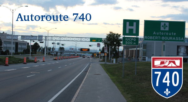
| Ville de Québec |
Northbound view showing the sign designating A-740 as Autoroute Robert-Bourassa. Photograph taken in July 2019. |
;) |
||
| Ville de Québec |
A look at the back of the above sign showing its weight in kilograms. It is information MTQ deems essential enough to put on each such sign nationwide. Photograph taken in July 2019. |
;) |
||
| Ville de Québec |
Northbound view approaching the Université Laval exit. Photograph taken in June 2023. |
;) |
||
| Ville de Québec |
Northbound view approaching the Université Laval exit. Photograph taken in July 2019. |
;) |
||
| Ville de Québec |
Southbound view approaching the Université Laval exit. Photograph taken in June 2023. |
;) |
||
| Ville de Québec |
Northbound view approaching the Chemin Ste-Foy/Chemin des Quatre-Bourgeois exit. Photograph taken in June 2023. |
;) |
||
| Ville de Québec |
Southbound view approaching the Université Laval exit. Photograph taken in June 2023. |
;) |
||
| Ville de Québec |
Southbound view approaching the Université Laval exit. Photograph taken in June 2023. |
;) |
||
| Ville de Québec |
Northbound view entering the tunnel. Photograph taken in June 2023. |
;) |
||
| Ville de Québec |
Southbound view passing through the tunnel. Photograph taken in June 2023. |
;) |
||
| Ville de Québec |
Northbound view passing through the tunnel. Photograph taken in June 2023. |
;) |
||
| Ville de Québec |
Southbound view entering the tunnel. Photograph taken in June 2023. |
;) |
||
| Ville de Québec |
Southbound view showing the 1 km advance signage for the Université Laval exit. Photograph taken in June 2023. |
;) |
||
| Ville de Québec |
Northbound view approaching the A-440 exits. Photograph taken in June 2023. |
;) |
||
| Ville de Québec |
Northbound view approaching the A-440 exits. Photograph taken in June 2023. |
;) |
||
| Ville de Québec |
Southbound view approaching the Chemin Ste-Foy/Chemin des Quatre-Bourgeois exit. Photograph taken in June 2023. |
;) |
||
| Ville de Québec |
Northbound view approaching the A-440 east exit. Photograph taken in June 2023. |
;) |
||
| Ville de Québec |
Northbound view approaching the A-440 east exit. Photograph taken in June 2023. |
;) |
||
| Ville de Québec |
Southbound view approaching the A-440 east exit. Photograph taken in June 2023. |
;) |
||
| Ville de Québec |
Northbound view passing under A-440. Photograph taken in June 2023. |
;) |
||
| Ville de Québec |
Southbound view approaching the A-440 east exit. Photograph taken in June 2023. |
;) |
||
| Ville de Québec |
Northbound view approaching the A-440 west exit. Photograph taken in June 2023. |
;) |
||
| Ville de Québec |
Southbound view approaching the A-440 west exit. Photograph taken in June 2023. |
;) |
||
| Ville de Québec |
Southbound view approaching the A-440 west exit. Photograph taken in June 2023. |
;) |
||
| Ville de Québec |
Northbound view passing the A-440 west exit. Photograph taken in June 2023. |
;) |
||
| Ville de Québec |
Southbound view approaching the Rue Jacquard/Rue Léon-Harmel/Rue Cyrille-Duquet exit. Photograph taken in June 2023. |
;) |
||
| Ville de Québec |
Northbound view passing the A-440 west exit. Photograph taken in June 2023. |
;) |
||
| Ville de Québec |
Southbound view approaching the Rue Jacquard/Rue Léon-Harmel/Rue Cyrille-Duquet exit. Photograph taken in June 2023. |
;) |
||
| Ville de Québec |
Northbound view approaching the R-138/Boulevard Wilfrid-Hamel exit. Photograph taken in June 2023. |
;) |
||
| Ville de Québec |
Northbound view approaching the R-138/Boulevard Wilfrid-Hamel exit. Photograph taken in June 2023. |
;) |
||
| Ville de Québec |
Northbound view passing the R-138/Boulevard Wilfrid-Hamel exit. Photograph taken in June 2023. |
;) |
||
| Ville de Québec |
Southbound view passing the R-138/Boulevard Wilfrid-Hamel exit. Photograph taken in June 2023. |
;) |
||
| Ville de Québec |
Northbound view approaching the Père-Lelièvre exit. Photograph taken in June 2023. |
;) |
||
| Ville de Québec |
Southbound view crossing the Rivière Saint-Charles. Photograph taken in June 2023. |
;) |
||
| Ville de Québec |
Southbound view approaching the R-138/Boulevard Wilfrid-Hamel exit. Photograph taken in June 2023. |
;) |
||
| Ville de Québec |
Northbound view passing the Père-Lelièvre exit. Photograph taken in June 2023. |
;) |
||
| Ville de Québec |
Southbound view at the Père-Lelièvre exit. Photograph taken in June 2023. |
;) |
||
| Ville de Québec |
Southbound view approaching the Père-Lelièvre exit. Photograph taken in June 2023. |
;) |
||
| Ville de Québec |
Northbound view approaching the A-40/A-73 exit. Photograph taken in June 2023. |
;) |
||
| Ville de Québec |
Southbound view showing the 800 m advance signage for the Père-Lelièvre exit. Photograph taken in June 2023. |
;) |
||
| Ville de Québec |
Southbound view passing the A-40/A-73 exit. Photograph taken in June 2023. |
;) |
||
| Ville de Québec |
Southbound view passing over A-40/A-73. Photograph taken in June 2023. |
;) |
||
| Ville de Québec |
Southbound view passing over A-40/A-73. Photograph taken in June 2023. |
;) |
||
© Curtis Walker. All rights reserved. All pictures used on this site are the property of the respective photographers and are used by permission. No picture may be used without the consent of the respective photographer.
All pictures taken by Curtis Walker unless otherwise noted.