Metro Route 125
 |
|
Pictures are arranged from east to west. Click here to show the route.
;)
| Route 125 ends at Route 62 (Osborne Street). Click here for Route 62 images. | ||||
| Location | Description | Photo
| ||
| City of Winnipeg |
Westbound view past Osborne Street.  Photograph taken in April 2009. |
;) |
||
| City of Winnipeg |
Westbound view near Riverdale Street. Photograph taken in October 2009. |
;) |
||
| City of Winnipeg |
Westbound view showing the new Clearview overhead signage for Pembina Highway. Though erroneously not indicated on this sign, there is a right-hand turnoff for southbound Pembina Highway available farther ahead. Photograph taken in August 2011. |
|||
| City of Winnipeg |
Westbound view near Pembina Highway. Photograph taken in April 2009. |
;) |
||
| City of Winnipeg |
Westbound view showing the advance signage for the turnoff for Route 42 south. Photograph taken in August 2011. |
;) |
||
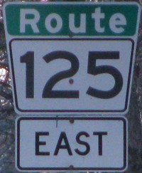
| City of Winnipeg |
Eastbound view showing the first eastbound marker. Photograph taken in April 2009. |
;) |
||
| City of Winnipeg |
Eastbound view showing a closeup of the first eastbound marker. Photograph taken in April 2009. |
;) |
||
| City of Winnipeg |
Westbound view at the turnoff for Route 42 south. Photograph taken in August 2011. |
;) |
||
| Route 125 ends at PTH 75/Route 42 (Pembina Highway). Click here for PTH 75 images and here for Route 42 images. | ||||
© Curtis Walker. All rights reserved. All pictures used on this site are the property of the respective photographers and are used by permission. No picture may be used without the consent of the respective photographer.
All pictures taken by Curtis Walker unless otherwise noted.