PTH 9A runs in a northwesterly direction through Selkirk, beginning and ending at PTH 9. Click here to show the route.
;)
Upon entering Selkirk from the south, PTH 9A follows Main Street, then turns west down Manitoba Avenue while PR 320 follows Main Street north. PTH 9A turns north west at Easton Drive meeting PTH 9 and PTH 4 past the Selkirk Recreation Complex.
Southern Terminus: Junction of PTH 9 south of Selkirk.
Northern Terminus: Junction of PTH 9/4 northwest of Selkirk.
Multiplexes: None.
Pictures are arranged from south to north.
| PTH 9A ends at PTH 9 south of Selkirk. Click here for PTH 9 images. | ||||
| Location | Description | Photo
| ||
| RM of St. Andrews |
Northbound view just north of the junction of PTH 9/9A showing the first reassurance marker for PTH 9A.  Photograph taken in June 2005. |
;) |
||
| RM of St. Andrews |
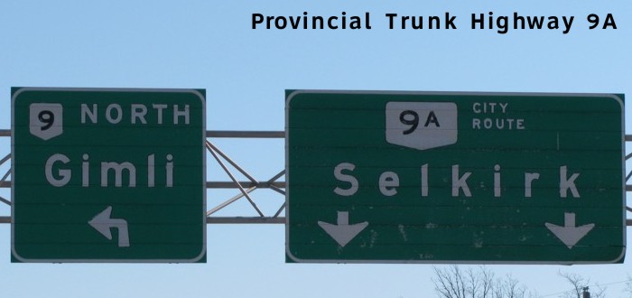
Southbound view at the junction of PTH 9 showing the sign giving directions to Winnipeg and Gimli. Photograph taken in May 2010. |
;) |
||
| RM of St. Andrews |
Southbound view showing the signs at the junction of PTH 9. Photograph taken in April 2009. |
;) |
||
| RM of St. Andrews |
Southbound view at the junction of PTH 9 showing the new Clearview signs for PTH 9. Photograph taken in May 2010. |
|||
| RM of St. Andrews |
Southbound view approaching the junction of PTH 9. Photograph taken in April 2009. |
;) |
||
| City of Selkirk |
Northbound view showing the sign entering Selkirk. Photograph taken in June 2005. |
;) |
||
| City of Selkirk |
A look at the front gate of Gerdau Ameristeel on Main Street, a Selkirk landmark and the city's largest private-sector employer. Photograph taken in March 2010. |
;) |
||
| City of Selkirk |
A look at the statue of “Chuck the Channel Cat.” Selkirk is known as the Catfish Capital of the World. Photograph taken in April 2014. |
;) |
||
| City of Selkirk |
Northbound view on Main Street passing the statue of “Chuck the Channel Cat.” Photograph taken in April 2014. |
;) |
||
| City of Selkirk |
Northbound view on Main Street at Strathnaver Avenue. Photograph taken in April 2009. |
;) |
||
| City of Selkirk |
Northbound view on Main Street approaching Vaughan Avenue. Photograph taken in April 2014. |
;) |
||
| City of Selkirk |
Northbound view approaching the junction of PR 204. Photograph taken in April 2009. |
;) |
||
| City of Selkirk |
Northbound view on Main Street approaching Eaton Avenue showing a closeup of the signage for PR 204. Photograph taken in April 2014. |
;) |
||
| City of Selkirk |
Southbound view on Main Street at Christie Avenue. Photograph taken in March 2010. |
;) |
||
| PTH 9A meets PR 204 at Eaton Avenue. Click here for PR 204 images. | ||||
| City of Selkirk |
Northbound view approaching the junction of PR 320. Photograph taken in April 2009. |
;) |
||
| City of Selkirk |
Southbound view on Main Street approaching the junction of PR 204 at Eaton Avenue. The first-generation sign for PR 204 is the last of a dying breed. Photograph taken in March 2010. |
;) |
||
| City of Selkirk |
Northbound view on Main Street approaching Manitoba Avenue showing a closeup of the signage for PR 320. Photograph taken in April 2014. |
;) |
||
| City of Selkirk |
Northbound view on Main Street at Manitoba Avenue showing the new marker for PTH 9A. Photograph taken in August 2011. |
|||
| PTH 9A meets PR 320 at Manitoba Avenue. Click here for PR 320 images. | ||||
| City of Selkirk |
Westbound view on Manitoba Avenue west of Main Street. Photograph taken in October 2009. |
;) |
||
| City of Selkirk |
Eastbound view on Manitoba Avenue showing the first marker east of Easton Drive. Photograph taken in October 2009. |
;) |
||
| City of Selkirk |
Westbound view on Manitoba Avenue at Easton Drive. Photograph taken in October 2009. |
;) |
||
| City of Selkirk |
Northbound view on Easton Drive north of Manitoba Avenue. Photograph taken in October 2009. |
;) |
||
| City of Selkirk |
Westbound view on Easton Drive approaching the junction of PTH 9/4. Photograph taken in October 2009. |
;) |
||
| City of Selkirk |
Westbound view on Easton Drive approaching the junction of PTH 9/4. Photograph taken in October 2009. |
;) |
||
| City of Selkirk |
Northbound view at the junction of PTH 9/4. Photograph taken in June 2006. |
;) |
||
| City of Selkirk |
Northbound view at the junction of PTH 9/4, showing a closeup of the markers. Photograph taken in June 2006. |
;) |
||
| PTH 9A ends at PTH 9/4 northwest of Selkirk. Click here for PTH 9 images and here for PTH 4 images. | ||||
© Curtis Walker. All rights reserved. All pictures used on this site are the property of the respective photographers and are used by permission. No picture may be used without the consent of the respective photographer.
All pictures taken by Curtis Walker unless otherwise noted.