|
Southern Terminus: Canada/Québec border, midspan on the Macdonald-Cartier International Bridge.
Northern Terminus: Junction of Route 105 in Wakefield. Click here to show the route. |
;)
Pictures are arranged from south to north.
| Location | Description | Photo
| ||
| City of Ottawa |
Northbound view on King Edward Avenue in neighboring Ottawa, Canada showing the trailblazer sign for A-5.  Photograph taken in May 2018. |
;) |
||
| City of Ottawa |
Looking northwest at the Macdonald-Cartier International Bridge from neighboring Canada. Photograph taken in April 2016. |
;) |
||
| City of Ottawa |
Westbound view from Sussex Drive in neighboring Ottawa, Canada showing the Macdonald-Cartier International Bridge. Photograph taken in April 2016. |
;) |
||
| City of Ottawa |
Westbound view from Sussex Drive in neighboring Ottawa, Canada showing the sign for the Macdonald-Cartier International Bridge. Photograph taken in April 2016. |
;) |
||
| Ville de Gatineau |
Westbound view on the Macdonald-Cartier International Bridge crossing the border into Québec. Photograph taken in April 2016. |
;) |
||
| Ville de Gatineau |
Westbound view on the Macdonald-Cartier International Bridge crossing the border into Québec. Photograph taken in April 2017. |
;) |
||
| Ville de Gatineau |
Westbound view on the Macdonald-Cartier International Bridge showing the 400 m advance signage for Exit 1. Photograph taken in April 2017. |
;) |
||
| Ville de Gatineau |
Eastbound view on the Macdonald-Cartier International Bridge leaving Québec and entering Canada. Photograph taken in April 2016. |
;) |
||
| Ville de Gatineau |
Eastbound view on the Macdonald-Cartier International Bridge approaching the Canadian border. Photograph taken in April 2016. |
;) |
||
| Ville de Gatineau |
Westbound view on the Macdonald-Cartier International Bridge showing the sign for Casino du Lac-Leamy at Exit 3. Photograph taken in April 2016. |
;) |
||
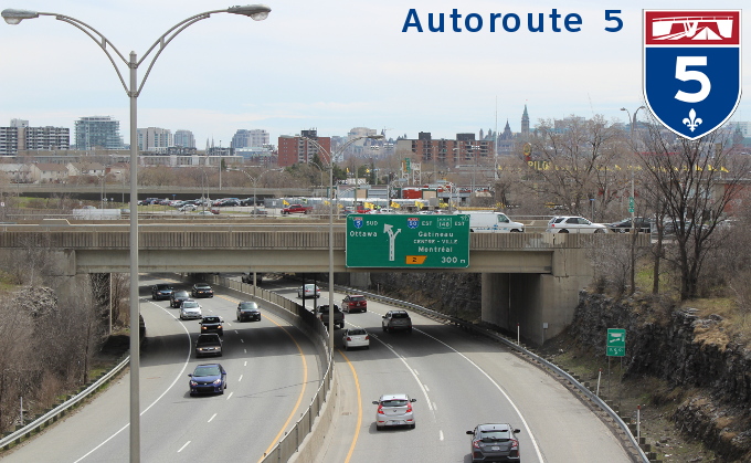
| Ville de Gatineau |
Eastbound view on the Macdonald-Cartier International Bridge showing the Parliament buildings in neighboring Ottawa, Canada. Photograph taken in April 2016. |
;) |
||
| Ville de Gatineau |
Looking northeast at the Macdonald-Cartier International Bridge. Photograph taken in April 2016. |
;) |
||
| Ville de Gatineau |
Westbound view showing the overhead signage at Exit 1 for Boulevards Maisonneuve and Fournier. Photograph taken in April 2016. |
;) |
||
| Ville de Gatineau |
Westbound view showing the overhead signage at Exit 1 as well as the sign welcoming visitors to Québec. Photograph taken in April 2017. |
;) |
||
| Ville de Gatineau |
Westbound view showing the sign welcoming visitors to Québec. Photograph taken in April 2016. |
;) |
||
| Ville de Gatineau |
Eastbound view from atop the overpass at Rue Laurier. In the distance on the other side of the Rivière des Outaouais is neighboring Ottawa, Canada. Photograph taken in April 2016. |
;) |
||
| Ville de Gatineau |
Eastbound view from atop the overpass at Rue Laurier overlooking neighboring Ottawa, Canada. Photograph taken in April 2017. |
;) |
||
| Ville de Gatineau |
Westbound view from atop the overpass at Rue Laurier. Photograph taken in April 2016. |
;) |
||
| Ville de Gatineau |
Westbound view from atop the overpass at Rue Laurier. Photograph taken in April 2017. |
;) |
||
| Ville de Gatineau |
Westbound view on Boulevard Sacré-Coeur showing the sign for the approach to A-5 off Boulevard Maisonneuve. Photograph taken in April 2016. |
;) |
||
| Ville de Gatineau |
Westbound view on Boulevard Sacré-Coeur showing the new sign for the approach to A-5 off Boulevard Maisonneuve. Photograph taken in May 2018. |
;) |
||
| Ville de Gatineau |
Northbound view on Boulevard Maisonneuve showing the overhead signage at the approaches to A-5. Photograph taken in April 2016. |
;) |
||
| Ville de Gatineau |
Southbound view on Boulevard Fournier at the turnoff to A-5 south. Photograph taken in April 2016. |
;) |
||
| Ville de Gatineau |
Westbound view from atop the overpass at Boulevard Fournier. Photograph taken in April 2016. |
;) |
||
| Ville de Gatineau |
Westbound view atop the overpass at Boulevard Fournier showing the overhead signage at Exit 2/A-50 east. Photograph taken in April 2016. |
;) |
||
| Ville de Gatineau |
Eastbound view from Boulevard Montclair showing the overhead signage at the A-50 exit. Photograph taken in April 2017. |
;) |
||
| Ville de Gatineau |
Eastbound view from Boulevard Montclair showing the overhead signage taking the A-50 exit. Photograph taken in April 2017. |
;) |
||
| Ville de Gatineau |
Southbound view from atop a pedestrian overpass off Boulevard Montclair showing the overhead signage at the A-50 exit. Photograph taken in April 2017. |
;) |
||
| Ville de Gatineau |
Southbound view on Boulevard de la Carrière showing the A-5 trailblazer sign. Photograph taken in April 2017. |
;) |
||
| Ville de Gatineau |
Southbound view on Boulevard de la Carrière showing the A-5 trailblazer sign. Photograph taken in May 2018. |
;) |
||
| Ville de Gatineau |
Westbound view on Boulevard Montclair showing the A-5 trailblazer sign. Photograph taken in May 2018. |
;) |
||
| Ville de Gatineau |
Northbound view from atop the overpass at Boulevard de la Carrière. Photograph taken in April 2017. |
;) |
||
| Ville de Gatineau |
Southbound view from atop the overpass at Rue des Galeries showing the 300 m advance signage for the A-50 exit. Photograph taken in April 2017. |
;) |
||
| Ville de Gatineau |
Northbound view on Boulevard Saint-Joseph showing the signage directing traffic for A-5 to the right at Boulevard du Casino. Photograph taken in April 2017. |
;) |
||
| Ville de Gatineau |
Southbound view from atop the overpass at Boulevard du Casino. Photograph taken in April 2017. |
;) |
||
| Ville de Gatineau |
Eastbound view on Boulevard du Casino showing the signage for the A-5 on-ramps. Photograph taken in April 2017. |
;) |
||
| Ville de Gatineau |
Eastbound view on Boulevard du Casino showing the signage at the A-5 north on-ramp. Photograph taken in April 2017. |
;) |
||
| Ville de Gatineau |
Westbound view on Boulevard du Casino showing the signage for the A-5 on-ramps. Photograph taken in April 2017. |
;) |
||
| Ville de Gatineau |
Westbound view on Boulevard du Casino showing the signage approaching the A-5 south on-ramp. Photograph taken in April 2017. |
;) |
||
| Ville de Gatineau |
Northbound view from atop the overpass at Boulevard du Casino. Photograph taken in April 2017. |
;) |
||
| Ville de Gatineau |
Northbound view on Boulevard Saint-Joseph showing the advance signage for the A-5 junction. Photograph taken in April 2017. |
;) |
||
| Ville de Gatineau |
Northbound view from Boulevard Saint-Joseph showing the overhead signage at Exit 5-S. Photograph taken in April 2017. |
;) |
||
| Ville de Gatineau |
Northbound view on Rue Jean-Proulx showing the sign near the A-5 north on-ramp. Photograph taken in April 2017. |
;) |
||
| Ville de Gatineau |
Northbound view on Rue Jean-Proulx showing the sign at the A-5 north on-ramp. Photograph taken in April 2017. |
;) |
||
| Ville de Gatineau |
A look at some old A-5 signs at an MTQ maintenance yard off Rue Jean-Proulx. Photograph taken in April 2017. |
;) |
||
| Ville de Gatineau |
Another look at some old A-5 signs at an MTQ maintenance yard off Rue Jean-Proulx. Photograph taken in April 2017. |
;) |
||
| Ville de Gatineau |
Southbound view from atop the overpass at Boulevard des Hautes-Plaines. Photograph taken in April 2017. |
;) |
||
| Ville de Gatineau |
Eastbound view on Boulevard des Hautes-Plaines showing the sign at the A-5 north on-ramp. Photograph taken in April 2017. |
;) |
||
| Ville de Gatineau |
Westbound view on Boulevard des Hautes-Plaines showing the signage for the A-5 on-ramps. Photograph taken in April 2017. |
;) |
||
| Ville de Gatineau |
Westbound view on Boulevard des Hautes-Plaines showing the sign at the A-5 south on-ramp. Photograph taken in April 2017. |
;) |
||
| Ville de Gatineau |
Eastbound view on Boulevard des Hautes-Plaines showing the signage for the A-5 on-ramps. Photograph taken in April 2017. |
;) |
||
| Ville de Gatineau |
Southbound view on Boulevard de la Cité-des-Jeunes at Boulevard des Hautes-Plaines showing the sign directing A-5 traffic to the left. Photograph taken in April 2017. |
;) |
||
| Ville de Gatineau |
Northbound view on Boulevard de la Cité-des-Jeunes at Boulevard des Hautes-Plaines showing the sign directing A-5 traffic to the right. Photograph taken in April 2017. |
;) |
||
| Ville de Gatineau |
Northbound view from atop the overpass at Boulevard des Hautes-Plaines. Photograph taken in April 2017. |
;) |
||
| Ville de Gatineau |
Northbound view from atop the overpass at Boulevard des Hautes-Plaines. Photograph taken in May 2018. |
;) |
||
© Curtis Walker. All rights reserved. All pictures used on this site are the property of the respective photographers and are used by permission. No picture may be used without the consent of the respective photographer.
All pictures taken by Curtis Walker unless otherwise noted.