|
Southern Terminus: Junction of A-5 in Gatineau.
Northern Terminus: Junction of Route 117 in Grand-Remous. Click here to show the route. |
;)
Pictures are arranged from south to north.
| Location | Description | Photo
| ||
| Ville de Gatineau |
Northbound view on Boulevard Saint-Joseph at the turn to A-5 south.  Photograph taken in April 2017. |
;) |
||
| Ville de Gatineau |
Southbound view on Boulevard Saint-Joseph at the turn for A-5 south. Photograph taken in April 2017. |
;) |
||
| Ville de Gatineau |
Northbound view on Boulevard Saint-Joseph showing the signage at the turn for A-5 north. Photograph taken in April 2017. |
;) |
||
| Ville de Gatineau |
Southbound view on Boulevard Saint-Joseph approaching the turn to A-5 south. The signage indicating that Boulevard Saint-Joseph continues ahead is correct, but R-105 officially ends at the A-5 interchange. Photograph taken in April 2017. |
;) |
||
| Ville de Gatineau |
Southbound view on Boulevard Saint-Joseph past Rue Jean-Proulx. Photograph taken in April 2017. |
;) |
||
| Ville de Gatineau |
Eastbound view on Rue Jean-Proulx approaching Boulevard Saint-Joseph showing the sign for R-105 and directing southbound A-5 traffic to the right. Passing in the distance is an STO bus, one of a fleet of largely dilapidated vehicles that most transit systems in neighboring Canada would be embarrassed to put on the road. Photograph taken in April 2017. |
;) |
||
| Ville de Gatineau |
Southbound from on Rue Jean-Proulx showing the advance signage for the junction of R-105. On the other side of the railing is the A-5 off-ramp. Photograph taken in April 2017. |
;) |
||
| Ville de Gatineau |
Southbound view on Boulevard Saint-Joseph showing more advance signage for the junction of A-5. Photograph taken in April 2017. |
;) |
||
| Ville de Gatineau |
Southbound view on Boulevard Saint-Joseph showing the advance signage for the junction of A-5. Photograph taken in April 2017. |
;) |
||
| Ville de Gatineau |
Southbound view on Boulevard Saint-Joseph past the roundabout at Rue Jean-Proulx. Photograph taken in April 2017. |
;) |
||
| Ville de Gatineau |
Northbound view on Boulevard Saint-Joseph at the roundabout at Rue Jean-Proulx. Photograph taken in April 2017. |
;) |
||
| Ville de Gatineau |
Southbound view on Boulevard Saint-Joseph at the roundabout at Rue Jean-Proulx. Photograph taken in April 2017. |
;) |
||
| Ville de Gatineau |
Southbound view on Boulevard Saint-Joseph at the roundabout at Rue Jean-Proulx. As the sign at right indicates, the local office of La Sûreté du Québec is at right. Photograph taken in April 2017. |
;) |
||
| Ville de Gatineau |
Southbound view on Boulevard Saint-Joseph approaching the roundabout at Rue Jean-Proulx. Photograph taken in April 2017. |
;) |
||
| Ville de Gatineau |
Southbound view on Boulevard Saint-Joseph approaching the roundabout at Rue Jean-Proulx. Photograph taken in April 2017. |
;) |
||
| Ville de Gatineau |
Southbound view on Boulevard Saint-Joseph at a traffic light past Chemin Freeman. At left is the local office of the SAAQ, Quebec's one and only auto insurer. In the Socialist People's Republic of Manitoba, their equivalent of the SAAQ is, without a doubt, the most reviled organization in the province. Photograph taken in April 2017. |
;) |
||
| Ville de Gatineau |
Southbound view on Boulevard Saint-Joseph past Chemin Freeman. Photograph taken in April 2017. |
;) |
||
| Ville de Gatineau |
Southbound view on Boulevard Saint-Joseph approaching Chemin Freeman. Photograph taken in April 2017. |
;) |
||
| Ville de Gatineau |
A look at the sign for Parc-o-bus Freeman on Boulevard Saint-Joseph. Parc-o-bus Freeman is a major STO stop and is popular with commuters, most of whom are Canada-bound. Photograph taken in April 2017. |
;) |
||
| Ville de Gatineau |
Northbound view on Boulevard Saint-Joseph past Chemin Freeman. Photograph taken in April 2017. |
;) |
||
| Ville de Gatineau |
Southbound view on Boulevard Saint-Joseph approaching Rue Juneau showing the signs directing traveles to TOP Karting and the Casino du Lac-Leamy. The Casino du Lac-Leamy is awfully popular with visitors and many of the major STO bus stops have a special marker indicating the route number that serves the casino. Photograph taken in April 2017. |
;) |
||
| Ville de Gatineau |
Southbound view on Boulevard Saint-Joseph approaching Rue Juneau. Photograph taken in April 2017. |
;) |
||
| Ville de Gatineau |
Southbound view on Boulevard Saint-Joseph approaching Rue Juneau. Photograph taken in April 2017. |
;) |
||
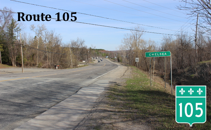
| Ville de Gatineau |
Northbound view on Boulevard Saint-Joseph leaving Gatineau and entering Chelsea. Photograph taken in April 2017. |
;) |
||
| Ville de Gatineau |
Northbound view showing the sign indicating entry into Chelsea. Photograph taken in April 2017. |
;) |
||
| MRC des Collines-de-l'Outaouais Municipalité de Chelsea |
A side view of the reference markers on either side of the sign for Chelsea. There are similar markers in New York, installed at every tenth of a mile on every highway in the state. Photograph taken in April 2017. |
;) |
||
| MRC des Collines-de-l'Outaouais Municipalité de Chelsea |
Northbound view showing the sign indicating the 70 km/h speed limit. Photograph taken in April 2017. |
;) |
||
| MRC des Collines-de-l'Outaouais Municipalité de Chelsea |
Northbound view showing the sign reminding drivers to give cyclists a wide berth. When the speed limit is more than 50 km/h, as it is on this stretch of R-105, drivers are required to give a cyclist 1.5 m of space when passing. Otherwise, the minimum distance is one meter, as it is in neighboring Ontario, Canada. Photograph taken in April 2017. |
;) |
||
| MRC des Collines-de-l'Outaouais Municipalité de Chelsea |
Northbound view showing an STO stop. Both STO and Transcollines service this area with public transit. Photograph taken in April 2017. |
;) |
||
| MRC des Collines-de-l'Outaouais Municipalité de Chelsea |
Northbound view showing a government propaganda sign, sadly not unique to Quebec. Given how much money Quebec sucks out of Canada, $3.6 of the $3.7M poured into this road probably came from the pockets of Canadian taxpayers, with the Quebec government complaining bitterly about having to fork over the extra $100,000. Photograph taken in April 2017. |
;) |
||
| MRC des Collines-de-l'Outaouais Municipalité de Chelsea |
Southbound view past Avenue du Pont. Photograph taken in April 2017. |
;) |
||
| MRC des Collines-de-l'Outaouais Municipalité de Chelsea |
Northbound view showing the first advance signage for the upcoming Avenue du Pont. Chelsea is accessible via R-105, while Cantley is accessible via R-307 on the other side of the Gatineau River. Photograph taken in April 2017. |
;) |
||
| MRC des Collines-de-l'Outaouais Municipalité de Chelsea |
Northbound view approaching Avenue du Pont. Photograph taken in April 2017. |
;) |
||
| MRC des Collines-de-l'Outaouais Municipalité de Chelsea |
Southbound view showing the reassurance marker past Avenue du Pont. This is the last southbound R-105 marker. Photograph taken in April 2017. |
;) |
||
| MRC des Collines-de-l'Outaouais Municipalité de Chelsea |
Northbound view at Avenue du Pont. Photograph taken in April 2017. |
;) |
||
| MRC des Collines-de-l'Outaouais Municipalité de Chelsea |
Southbound view on Avenue du Pont at the R-105 junction. Photograph taken in April 2017. |
;) |
||
| MRC des Collines-de-l'Outaouais Municipalité de Chelsea |
Southbound view on Avenue du Pont showing advance signage for the R-105 junction. Photograph taken in April 2017. |
;) |
||
| MRC des Collines-de-l'Outaouais Municipalité de Chelsea |
A look at the back of the above sign assembly. The R-105 marker is a recycled former R-132 marker. Photograph taken in April 2017. |
;) |
||
| MRC des Collines-de-l'Outaouais Municipalité de Chelsea |
Westbound view on Avenue du Pont showing the advance signage for the R-105 junction. Photograph taken in April 2017. |
;) |
||
| MRC des Collines-de-l'Outaouais Municipalité de Chelsea |
Northbound view past Avenue du Pont. Photograph taken in April 2017. |
;) |
||
| MRC des Collines-de-l'Outaouais Municipalité de Chelsea |
Southbound view approaching Avenue du Pont. Cantley is accessible via R-307 on the opposite side of the Gatineau River. Photograph taken in April 2017. |
;) |
||
© Curtis Walker. All rights reserved. All pictures used on this site are the property of the respective photographers and are used by permission. No picture may be used without the consent of the respective photographer.
All pictures taken by Curtis Walker unless otherwise noted.