 |
 |
|
 |
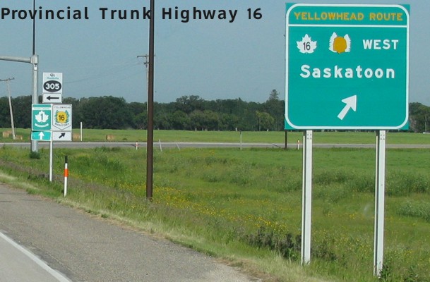
PTH 16 comprises the majority of the historic and well-travelled Yellowhead Highway across central and western Manitoba. Beginning at the junction of PTH 1/PR 305 west of Portage la Prairie, the route proceeds on a northwesterly course through Neepawa, around Minnedosa, and through Russell on its way to Yorkton, Saskatoon, the Battlefords, Lloydminster and Edmonton. The route continues westward through the Yellowhead Pass and ends at Prince Rupert, BC. Click here to show the route.
;)
Despite its importance as a vital transportation link in Western Canada, the portion of the route through Manitoba is two-lane through most of its length and only rarely are the shoulders even paved.
This route was originally known as PTH 4 and was redesignated as PTH 16 in 1977 as the route number of the Yellowhead Highway was standardized as 16 across all four western provinces. Saskatchewan had renumbered its portion of the Yellowhead Highway the previous year.
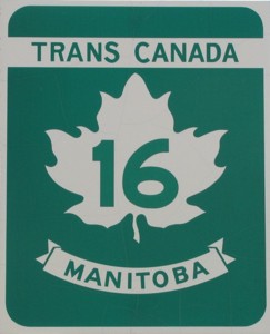
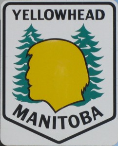
Regrettably, in the 1980s, the route's primary distinctive Yellowhead signage was replaced with Trans Canada signage. Though the Yellowhead marker continues to be displayed along the route, it has been relegated to little more than a ceremonial designation alongside the green Trans Canada marker. This decision was particularly unwise, since it creates ambiguity with PTH 1, the “main” Trans Canada Highway, and since PTH 16 has been and continues to be known as simply “The Yellowhead”, despite efforts to promote it as a second Trans Canada Highway.
At the Johnston Terminal at the Government Forks in downtown Winnipeg, there is a display commemorating the Yellowhead Highway, pictured below:
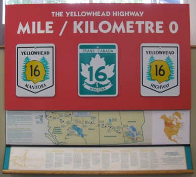
Following is the text of what is printed on the display:
Mile “0” (Kilometer “0”) of the Yellowhead Highway
Six thousand years ago, the junction of the Red and Assiniboine Rivers was a gathering place for Aboriginal peoples. Today, this area is known as The Forks, the birthplace of Winnipeg, and Mile “0” of the Yellowhead Highway. As you stand poised at the Mile “0” marker, we invite you to ponder, for a moment or two, the historic significance of this major roadway and its correlation to The Forks.
A number of trails of both an earlier and later vintage are remembered in Canada's history books. The greatest of them, the Old North-West Trail, extending from the historic site of Upper Fort Garry to Edmonton and beyond, can be best described as the forerunner to the present Yellowhead Highway.
The West's most famous trail was known by many names. It was also referred to as the Carlton Trail, the Old Saskatchewan Trail, the Portage Trail, the Old Edmonton Trail, and the Hudson's Bay Trail.
When the Great Buffalo Hunt of 1840 was organized, no less than 1,210 Red River carts took the trail west from Upper Fort Garry onto the south-west plains. It was truly the beginning of the Yellowhead as we know it today.
Welcome to Yellowhead Country!
The Trans Canada Yellowhead boasts excellent year-round road conditions, hundreds of kilometers of four-lane highway with wide shoulders and gentle mountain grades and contours. It's easy to enjoy the drive, especially since the Yellowhead is the only highway that travels between the mountains instead of over them. That means lower fuel bills, less vehicle wear and tear, and spectacular scenery!
The Yellowhead is also the only Trans Canada Highway that gives you access to three west coast ports - Prince Rupert, Vancouver and Kitimat - with connections to the Yukon Territory and Alaska via the Alaska Highway.
From the multicultural capital city of Winnipeg, take the Trans Canada Yellowhead westward and discover attractions as unique as the landscape. And the Yellowhead puts North America's largest, rarest, most majestic animals and birds within easy reach of your camera. So choose your own style, set your own pace, and come see the many faces of the Trans Canada Yellowhead Highway!
How the Route Got Its Name
The Yellowhead Highway, the Yellowhead Pass and Tête Jaune Cache were named after an Iroquois metis guide. His name was Pierre Bostonais, but the French voyageurs called him “Tête Jaune,” or “yellow-head,” because of his blonde-streaked hair.
Tête Jaune worked for the Hudson's Bay Company as a guide, and the few written records available on his travels are contained in that company's journals and correspondence.
Today, the mountain pass he opened to trade is called the Yellowhead Pass, and the modern highway that crosses it, the Trans Canada Yellowhead Highway.
Images of PTH 16:
|
|
|
© Curtis Walker. All rights reserved. All pictures used on this site are the property of the respective photographers and are used by permission. No picture may be used without the consent of the respective photographer.
All pictures taken by Curtis Walker unless otherwise noted.