|
Western Terminus: Junction of I-80/PA 760 near Hermitage.
Eastern Terminus: Junction of I-76/US 22 in Monroeville. Click here to show the route. |
;)
Pictures are arranged from west to east.
| Location | Description | Photo
| ||
| Allegheny County Collier Township |
Eastbound view passing under the I-79 south on-ramp.  Photograph taken in May 2017. |
;) |
||
| Allegheny County Collier Township |
Eastbound view passing under the I-79 south on-ramp. Photograph taken in May 2017. |
;) |
||
| Allegheny County Robinson Township |
Eastbound view as traffic merges from northbound I-79. Photograph taken in May 2017. |
;) |
||
| Allegheny County Borough of Rosslyn Farms |
Eastbound view showing the 1 mile advance signage for Exit 65/PA 50. Photograph taken in May 2017. |
;) |
||
| Allegheny County Borough of Rosslyn Farms |
Eastbound view passing under the eastbound on-ramp from Rosslyn Road. Photograph taken in May 2017. |
;) |
||
| Allegheny County Borough of Carnegie |
Eastbound view showing the advisory sign for PPG Arena, the convention center and north shore destinations. Photograph taken in May 2017. |
;) |
||
| Allegheny County Borough of Carnegie |
Eastbound view approaching Exit 65. Photograph taken in May 2017. |
;) |
||
| Allegheny County Borough of Carnegie |
Eastbound view showing the overhead signage giving the driving time to the Fort Pitt Tunnel. Photograph taken in May 2017. |
;) |
||
| Allegheny County Borough of Carnegie |
Eastbound view showing the ¼ mile advance signage for Exit 65. Photograph taken in May 2017. |
;) |
||
| Allegheny County Scott Township |
Eastbound view at Exit 65. Photograph taken in May 2017. |
;) |
||
| Allegheny County Scott Township |
Eastbound view passing Exit 65 showing the 1¾ mile advance signage for Exit 67/PA 121. Photograph taken in May 2017. |
;) |
||
| Allegheny County Scott Township |
Eastbound view passing Exit 65. Photograph taken in May 2017. |
;) |
||
| Allegheny County Borough of Green Tree |
Eastbound view showing the advisory sign for PNC Park and Heinz Field. Both stadiums are on the north shore and are accessible via a left exit past the Fort Pitt Tunnel onto the Fort Duquesne Bridge. Photograph taken in May 2017. |
;) |
||
| Allegheny County Borough of Green Tree |
Eastbound view showing the 1 mile advance signage for Exit 67. Photograph taken in May 2017. |
;) |
||
| Allegheny County Borough of Green Tree |
Eastbound view showing the 1 mile advance signage for Exit 67. Photograph taken in May 2017. |
;) |
||
| Allegheny County Borough of Green Tree |
Eastbound view approaching Exit 67. In the distance to the left is the building for WDVE-FM, the current radio home of the Pittsburgh Steelers. Photograph taken in May 2017. |
;) |
||
| Allegheny County Borough of Green Tree |
Eastbound view approaching Exit 67. Photograph taken in May 2017. |
;) |
||
| Allegheny County Borough of Green Tree |
Eastbound view past Exit 67 showing the 1½ mile advance signage for the Fort Pitt Tunnel. Photograph taken in May 2017. |
;) |
||
| Allegheny County City of Pittsburgh |
Eastbound view past Exit 67. Photograph taken in May 2017. |
;) |
||
| Allegheny County City of Pittsburgh |
Eastbound view showing the 1 mile advance signage for Exit 69 B&C/US 19/PA 51. Photograph taken in May 2017. |
;) |
||
| Allegheny County City of Pittsburgh |
Eastbound view approaching Exit 69. Photograph taken in May 2017. |
;) |
||
| Allegheny County City of Pittsburgh |
Eastbound view showing the ¾ mile advance signage for Exit 69 B&C. Photograph taken in May 2017. |
;) |
||
| Allegheny County City of Pittsburgh |
Eastbound showing the triumvirate of markers. US 22 and US 30 run concurrently with I-376 through Pittsburgh. Photograph taken in May 2017. |
;) |
||
| Allegheny County City of Pittsburgh |
Eastbound view showing the advisory sign for the upcoming Pittsburgh exits. Photograph taken in May 2017. |
;) |
||
| Allegheny County City of Pittsburgh |
Eastbound view at a runaway truck ramp. There is a steep downgrade approaching the Fort Pitt Tunnel. Photograph taken in May 2017. |
;) |
||
| Allegheny County City of Pittsburgh |
Eastbound view passing the runaway truck ramp approaching Exits 69B&C. Photograph taken in May 2017. |
;) |
||
| Allegheny County City of Pittsburgh |
Eastbound view approaching Exits 69B&C. At left is the 1¼ mile advance signage for I-279, which is a left exit on the Fort Pitt Bridge. Photograph taken in May 2017. |
;) |
||
| Allegheny County City of Pittsburgh |
Eastbound view at Exit 69B. Photograph taken in May 2017. |
;) |
||
| Allegheny County City of Pittsburgh |
Eastbound view at Exit 69C. This is the last exit before the Fort Pitt Tunnel. Photograph taken in May 2017. |
;) |
||
| Allegheny County City of Pittsburgh |
Eastbound view passing Exit 69C. Photograph taken in May 2017. |
;) |
||
| Allegheny County City of Pittsburgh |
Eastbound view entering the Fort Pitt Tunnel. The tunnel, which goes through Mount Washington, was opened in 1960 and is just over a kilometer in length. Photograph taken in May 2017. |
;) |
||
| Allegheny County City of Pittsburgh |
Eastbound view entering the Fort Pitt Tunnel. Photograph taken in May 2017. |
;) |
||
| Allegheny County City of Pittsburgh |
Eastbound view passing through the Fort Pitt Tunnel. Photograph taken in May 2017. |
;) |
||
| Allegheny County City of Pittsburgh |
Eastbound view passing through the Fort Pitt Tunnel. Photograph taken in May 2017. |
;) |
||
| Allegheny County City of Pittsburgh |
Eastbound view passing through the Fort Pitt Tunnel. Photograph taken in May 2017. |
;) |
||
| Allegheny County City of Pittsburgh |
Eastbound view passing through the Fort Pitt Tunnel. Photograph taken in May 2017. |
;) |
||
| Allegheny County City of Pittsburgh |
Eastbound view passing through the Fort Pitt Tunnel. Photograph taken in May 2017. |
;) |
||
| Allegheny County City of Pittsburgh |
Eastbound view passing through the Fort Pitt Tunnel. Photograph taken in May 2017. |
;) |
||
| Allegheny County City of Pittsburgh |
Eastbound view exiting the Fort Pitt Tunnel and onto the adjacent Fort Pitt Bridge that crosses the Monongahela River. Photograph taken in May 2017. |
;) |
||
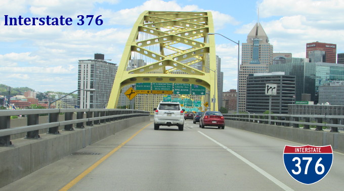
| Allegheny County City of Pittsburgh |
Eastbound view at Exits 70A, B and C. I-376 traffic proceeds along the shore to the right, traffic headed into downtown proceeds straight ahead, while I-279 traffic proceeds to the left over the Fort Duquesne Bridge. Photograph taken in May 2017. |
;) |
||
| Allegheny County City of Pittsburgh |
Looking southwest at the Fort Pitt Bridge from Point State Park. Traffic headed into downtown uses the top deck, while traffic bound for the tunnel uses the bottom deck. Photograph taken in May 2017. |
;) |
||
| Allegheny County City of Pittsburgh |
Eastbound view on Boulevard of the Allies showing a trailblazer sign for I-376. Interstate signs with the state on it like this one are the last of a dying breed. Photograph taken in May 2017. |
;) |
||
© Curtis Walker. All rights reserved. All pictures used on this site are the property of the respective photographers and are used by permission. No picture may be used without the consent of the respective photographer.
All pictures taken by Curtis Walker unless otherwise noted.