 |
|
Pictures are arranged from west to east. Click here to show the route.
;)
| Location | Description | Photo
| ||
| I-94 meets US 281 in Jamestown. Click here for US 281 images. | ||||
| I-94 meets US 10 in West Fargo. Click here for US 10 images. | ||||
| I-94 meets I-29/US 81 in Fargo. Click here for I-29 images. | ||||
| Cass County City of Fargo |
Eastbound view approaching I-94 from the southbound exit off I-29/US 81.  Photograph taken in November 2009. |
;) |
||
| Cass County City of Fargo |
Westbound view showing the sign for Exit 349B. Photograph taken in November 2009. |
;) |
||
| Cass County City of Fargo |
Eastbound view approaching I-94 from the southbound exit off I-29/US 81. Photograph taken in November 2009. |
;) |
||
| Cass County City of Fargo |
Westbound view showing a closeup of the signage for Exits 349 A/B. Photograph taken in November 2009. |
;) |
||
| Cass County City of Fargo |
Westbound view approaching Exits 349 A/B, the junction of I-29/US 81. Photograph taken in November 2007. |
;) |
||
| Cass County City of Fargo |
Westbound view approaching Exits 349 A/B. Photograph taken in November 2009. |
;) |
||
| Cass County City of Fargo |
Westbound view approaching Exits 349 A/B. Photograph taken in November 2009. |
;) |
||
| Cass County City of Fargo |
Eastbound view near Exit 350 for 25th Street. Photograph taken in November 2009. |
;) |
||
| Cass County City of Fargo |
Eastbound view at Exit 350. Photograph taken in January 2010. |
;) |
||
| Cass County City of Fargo |
Westbound view approaching Exits 349 A/B. Photograph taken in November 2009. |
;) |
||
| Cass County City of Fargo |
Westbound view approaching Exits 349 A/B. Photograph taken in November 2009. |
;) |
||
| Cass County City of Fargo |
Eastbound view passing Exit 350. Photograph taken in November 2009. |
;) |
||
| Cass County City of Fargo |
Westbound view passing Exit 350 showing the advance signage for Exits 349A/B. Photograph taken in November 2009. |
;) |
||
| Cass County City of Fargo |
Westbound view passing Exit 350. Photograph taken in November 2009. |
;) |
||
| Cass County City of Fargo |
Eastbound view passing Exit 350. Photograph taken in November 2009. |
;) |
||
| Cass County City of Fargo |
Westbound view approaching Exit 350. Photograph taken in November 2009. |
;) |
||
| Cass County City of Fargo |
Eastbound view approaching Exit 351. Photograph taken in November 2009. |
;) |
||
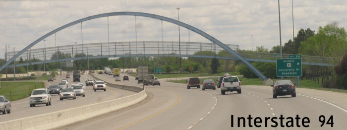
| Cass County City of Fargo |
Eastbound view approaching Exit 351. Ahead is a foot bridge that crosses I-94. Photograph taken in November 2009. |
;) |
||
| Cass County City of Fargo |
Eastbound view approaching Exit 351. Photograph taken in May 2012. |
;) |
||
| Cass County City of Fargo |
Westbound view approaching Exit 350. Photograph taken in November 2009. |
;) |
||
| Cass County City of Fargo |
Eastbound view at Exit 351. This is the last exit before I-94 crosses the Red River into Minnesota. Photograph taken in November 2009. |
;) |
||
| Cass County City of Fargo |
Westbound view passing Exit 351. Photograph taken in November 2009. |
;) |
||
| Cass County City of Fargo |
Eastbound view passing Exit 351. Photograph taken in November 2009. |
;) |
||
| Cass County City of Fargo |
Eastbound view showing the 1 mile advance signage for Exit 1A/US 75 in Minnesota. Photograph taken in May 2012. |
;) |
||
| Cass County City of Fargo |
Westbound view approaching Exit 351. Photograph taken in November 2009. |
;) |
||
| Cass County City of Fargo |
Eastbound view passing Exit 351. Photograph taken in January 2010. |
;) |
||
| Cass County City of Fargo |
Eastbound view past Exit 351 approaching the bridge that crosses the Red River. Photograph taken in November 2009. |
;) |
||
| Cass County City of Fargo |
Eastbound view past Exit 351. Photograph taken in January 2010. |
;) |
||
| Cass County City of Fargo |
Eastbound view past Exit 351 approaching the bridge that crosses the Red River. Photograph taken in May 2012. |
;) |
||
| Cass County City of Fargo |
Westbound view showing a closeup of the advance signage for Exit 351. Photograph taken in November 2009. |
;) |
||
| Cass County City of Fargo |
Westbound view entering North Dakota showing the advance signage for Exit 351. Photograph taken in November 2009. |
;) |
||
| Cass County City of Fargo |
Eastbound view crossing the Red River into Minnesota. Ahead is the advance signage for Exit 1A in Moorhead. Photograph taken in November 2009. |
;) |
||
| I-94 continues east into Minnesota. Click here for I-94 images in Minnesota. | ||||
© Curtis Walker. All rights reserved. All pictures used on this site are the property of the respective photographers and are used by permission. No picture may be used without the consent of the respective photographer.
All pictures taken by Curtis Walker unless otherwise noted.