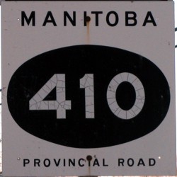
Provincial Road 410
 |
|
Pictures are arranged from east to west. Click here to show the route.
| PR 410 ends at PR 238. Click here for PR 238 images. | ||||
| Location | Description | Photo
| ||
| RM of St. Andrews |
Eastbound view at the junction of PR 238 showing the high water level on the Red River.  Photograph taken in April 2009. |
 |
||
| RM of St. Andrews |
Eastbound view at the junction of PR 238.  Photograph taken in September 2005. |
 |
||
| RM of St. Andrews |
A view of the sign outside historic St. Andrews Church on the north side of PR 410.  Photograph taken in April 2009. |
 |
||
| RM of St. Andrews |
A view of historic St. Andrews Church on the north side of PR 410.  Photograph taken in April 2009. |
 |
||
| RM of St. Andrews |
Eastbound view showing the sign for the St. Andrews Rectory, a national historic site.  Photograph taken in April 2009. |
 |
||
| RM of St. Andrews |
Eastbound view showing the advance signage for the junction of PR 238.  Photograph taken in April 2009. |
 |
||
| RM of St. Andrews |
Westbound view showing the advance signage for the junction of PTH 9.  Photograph taken in April 2009. |
 |
||
| RM of St. Andrews |
Westbound view at the junction of PTH 9.  Photograph taken in April 2009. |
 |
||
| RM of St. Andrews |
Westbound view at the junction of PTH 9.  Photograph taken in June 2011. |
 |
||
| RM of St. Andrews |
Westbound view at the junction of PTH 9 showing a closeup of the markers.  Photograph taken in June 2011. |
 |
||
| PR 410 meets PTH 9 south of Lockport. Click here for PTH 9 images. | ||||
| RM of St. Andrews |
Westbound view showing the first marker west of PTH 9.  Photograph taken in June 2011. |
 |
||
| RM of St. Andrews |
Westbound view showing a closeup of the first marker west of PTH 9.  Photograph taken in June 2011. |
 |
||
| RM of St. Andrews |
Eastbound view showing the first eastbound marker.  Photograph taken in May 2009. |
 |
||
| RM of St. Andrews |
Westbound view at the junction of PR 230.  Photograph taken in May 2009. |
 |
||
| RM of St. Andrews |
Westbound view at the junction of PR 230 showing a closeup of the markers.  Photograph taken in May 2009. |
 |
||
| PR 410 ends at PR 230. Click here for PR 230 images. | ||||
© Curtis Walker. All rights reserved. All pictures used on this site are the property of the respective photographers and are used by permission. No picture may be used without the consent of the respective photographer.
All pictures taken by Curtis Walker unless otherwise noted.