 |
|
Pictures are arranged from south to north. Click here to show the route.
;)
| PR 340 ends at PTH 2 south of Wawanesa. Click here for PTH 2 images. | ||||
| Location | Description | Photo
| ||
| RM of Oakland |
Southbound view at the junction of PTH 2.  Photograph taken in August 2010. |
;) |
||
| Village of Wawanesa |
Northbound view showing the first northbound reassurance marker. Photograph taken in August 2010. |
;) |
||
| Village of Wawanesa |
Northbound view showing the first northbound reassurance marker. Photograph taken in August 2010. |
;) |
||
| Village of Wawanesa |
Southbound view approaching the junction of PTH 2. Photograph taken in August 2010. |
;) |
||
| Village of Wawanesa |
Northbound view past the first northbound reassurance marker. Photograph taken in August 2010. |
;) |
||
| Village of Wawanesa |
Southbound view showing the advance signage for the junction of PTH 2. Photograph taken in August 2010. |
;) |
||
| Village of Wawanesa |
Northbound view past the first northbound reassurance marker. Photograph taken in August 2010. |
;) |
||
| Village of Wawanesa |
Southbound view approaching the junction of PTH 2. Photograph taken in August 2010. |
;) |
||
| Village of Wawanesa |
Northbound view approaching the sign indicating the entry into Wawanesa. Like many such signs in Manitoba, this sign is not accurate, since the village limits are farther south near the junction of PTH 2. Photograph taken in August 2010. |
;) |
||
| Village of Wawanesa |
Southbound view past Government Road. Photograph taken in August 2010. |
;) |
||
| Village of Wawanesa |
Northbound view at Government Road. Photograph taken in August 2010. |
;) |
||
| Village of Wawanesa |
Southbound view approaching Government Road. Photograph taken in August 2010. |
;) |
||
| Village of Wawanesa |
Northbound view showing the advance signage for the junction of PR 344. Photograph taken in August 2010. |
;) |
||
| Village of Wawanesa |
Northbound view showing the advance signage for the junction of PR 344. Photograph taken in August 2010. |
;) |
||
| Village of Wawanesa |
Southbound view approaching Government Road. Photograph taken in August 2010. |
;) |
||
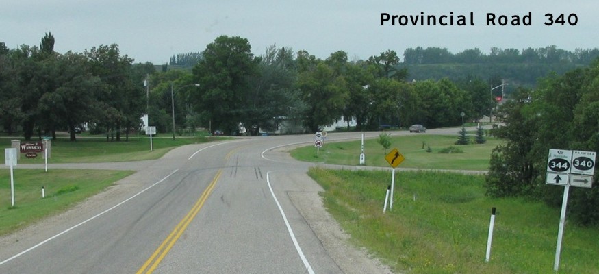
| Village of Wawanesa |
Northbound view approaching the junction of PR 344. Photograph taken in August 2010. |
;) |
||
| PR 340 meets PR 344 in Wawanesa. Click here for PR 344 images. | ||||
| Village of Wawanesa |
Southbound view showing the first southbound marker past the junction of PR 344. Photograph taken in August 2010. |
;) |
||
| Village of Wawanesa |
Northbound view from Main Street. Photograph taken in August 2010. |
;) |
||
| Village of Wawanesa |
Southbound view near the junction of PR 344. Photograph taken in August 2010. |
;) |
||
| Village of Wawanesa |
Northbound view north of Main Street. Photograph taken in August 2010. |
;) |
||
| RM of Cornwallis |
Southbound view approaching Waggle Springs Road. Photograph taken in October 2013. |
;) |
||
| RM of Cornwallis |
Northbound view approaching the junction of PR 457. Photograph taken in October 2013. |
;) |
||
| RM of Cornwallis |
Northbound view approaching the junction of PR 457. Photograph taken in October 2013. |
;) |
||
| RM of Cornwallis |
Northbound view passing the junction of PR 457. Photograph taken in October 2013. |
;) |
||
| PR 340 meets PR 457 south of Douglas. Click here for PR 457 images. | ||||
| RM of Cornwallis |
Northbound view past the junction of PR 457. Photograph taken in October 2013. |
;) |
||
| RM of Cornwallis |
Northbound view past the junction of PR 457. Photograph taken in October 2013. |
;) |
||
| RM of Cornwallis |
Northbound view past the junction of PR 457. Photograph taken in October 2013. |
;) |
||
| RM of Cornwallis |
Northbound view past the junction of PR 457. Photograph taken in October 2013. |
;) |
||
| RM of Cornwallis |
Northbound view approaching Richardson Road. Photograph taken in October 2013. |
;) |
||
| RM of Elton |
Northbound view past Richardson Road. Photograph taken in October 2013. |
;) |
||
| RM of Elton |
Northbound view approaching Douglas. Photograph taken in October 2013. |
;) |
||
| RM of Elton |
Northbound view approaching Douglas. Photograph taken in October 2013. |
;) |
||
| RM of Elton |
Northbound view approaching Douglas. Photograph taken in October 2013. |
;) |
||
| RM of Elton |
Northbound view approaching Douglas. Photograph taken in October 2013. |
;) |
||
| RM of Elton |
Northbound view approaching Douglas. Photograph taken in October 2013. |
;) |
||
| RM of Elton |
Northbound view entering Douglas. Photograph taken in October 2013. |
;) |
||
| RM of Elton |
Eastbound view on South Railway Street. Photograph taken in October 2013. |
;) |
||
| RM of Elton |
Northbound view on Broadway Street at the railway crossing. Photograph taken in October 2013. |
;) |
||
| RM of Elton |
Eastbound view on Railway Sreet. Photograph taken in October 2013. |
;) |
||
| RM of Elton |
Eastbound view on Railway Sreet past Rothesay Street. Photograph taken in October 2013. |
;) |
||
| RM of Elton |
Northbound view leaving Douglas. Photograph taken in October 2013. |
;) |
||
| RM of Elton |
Northbound view leaving Douglas. Photograph taken in October 2013. |
;) |
||
| RM of Elton |
Northbound view showing the advance signage for the junction of PTH 1. Photograph taken in October 2013. |
;) |
||
| RM of Elton |
Northbound view approaching the junction of PTH 1. Photograph taken in October 2013. |
;) |
||
| RM of Elton |
Northbound view approaching the junction of PTH 1. Photograph taken in October 2013. |
;) |
||
| RM of Elton |
Northbound view approaching the junction of PTH 1. Photograph taken in October 2013. |
;) |
||
| RM of Elton |
Northbound view approaching the junction of PTH 1. Photograph taken in October 2013. |
;) |
||
| PR 340 ends at PTH 1 north of Douglas. Click here for PTH 1 images. | ||||
© Curtis Walker. All rights reserved. All pictures used on this site are the property of the respective photographers and are used by permission. No picture may be used without the consent of the respective photographer.
All pictures taken by Curtis Walker unless otherwise noted.