 |
|
Pictures are arranged from west to east. Click here to show the route.
;)
| PR 313 ends at |
||||
| Location | Description | Photo
| ||
| RM of Lac du Bonnet |
Westbound view at the junction of PTH 11.  Photograph taken in July 2012. |
;) |
||
| RM of Lac du Bonnet |
Eastbound view past the junction of PTH 11. Photograph taken in July 2012. |
;) |
||
| RM of Lac du Bonnet |
Westbound view approaching the junction of PTH 11. Photograph taken in July 2012. |
;) |
||
| RM of Lac du Bonnet |
Eastbound view showing the 2 km advance signage for the turnoff to the Lac du Bonnet Airport. Photograph taken in July 2012. |
;) |
||
| RM of Lac du Bonnet |
Westbound view approaching the junction of PTH 11. Photograph taken in July 2012. |
;) |
||
| RM of Lac du Bonnet |
Westbound view approaching the junction of PTH 11. Photograph taken in July 2012. |
;) |
||
| RM of Lac du Bonnet |
Westbound view approaching the junction of PTH 11. Photograph taken in July 2012. |
;) |
||
| RM of Lac du Bonnet |
Westbound view showing the advance signage for the junction of PTH 11. Photograph taken in July 2012. |
;) |
||
| RM of Lac du Bonnet |
Eastbound view approaching Hard Rock Road. Photograph taken in July 2012. |
;) |
||
| RM of Lac du Bonnet |
Westbound view approaching Hard Rock Road. Photograph taken in July 2012. |
;) |
||
| RM of Lac du Bonnet |
Eastbound view showing the advance signage for the junction of PR 502. Photograph taken in July 2012. |
;) |
||
| RM of Lac du Bonnet |
Eastbound view showing the sign giving the distances to Bird Lake and Pointe du Bois. Bird Lake is located in the southern part of Nopiming Provincial Park off PR 315. Photograph taken in July 2012. |
;) |
||
| RM of Lac du Bonnet |
Eastbound view approaching the junction of PR 502. Photograph taken in July 2012. |
;) |
||
| RM of Lac du Bonnet |
Westbound view passing the junction of PR 502. Photograph taken in July 2012. |
;) |
||
| PR 313 meets PR 502 north east of Lac du Bonnet. Click here for PR 502 images. | ||||
| RM of Lac du Bonnet |
Eastbound view passing the junction of PR 502. Photograph taken in July 2012. |
;) |
||
| RM of Lac du Bonnet |
Westbound view approaching the junction of PR 502. Photograph taken in July 2012. |
;) |
||
| RM of Lac du Bonnet |
Westbound view approaching Airport Road. Photograph taken in July 2012. |
;) |
||
| RM of Lac du Bonnet |
Eastbound view approaching the crossing of the Winnipeg River. Photograph taken in July 2012. |
;) |
||
| RM of Lac du Bonnet |
Westbound view past the crossing of the Winnipeg River. Photograph taken in July 2012. |
;) |
||
| RM of Lac du Bonnet |
Eastbound view approaching the crossing of the Winnipeg River. Photograph taken in July 2012. |
;) |
||
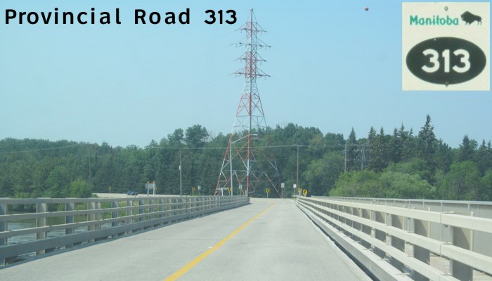
| RM of Lac du Bonnet |
Westbound view on the bridge crossing the Winnipeg River. Photograph taken in July 2012. |
;) |
||
| RM of Lac du Bonnet |
Eastbound view on the bridge crossing the Winnipeg River. Photograph taken in July 2012. |
;) |
||
| RM of Lac du Bonnet |
Westbound view on the bridge crossing the Winnipeg River. Photograph taken in July 2012. |
;) |
||
| RM of Lac du Bonnet |
Eastbound view on the bridge crossing the Winnipeg River. Photograph taken in July 2012. |
;) |
||
| RM of Lac du Bonnet |
Westbound view on the bridge crossing the Winnipeg River. Photograph taken in July 2012. |
;) |
||
| RM of Lac du Bonnet |
Westbound view on the bridge crossing the Winnipeg River. Photograph taken in July 2012. |
;) |
||
| RM of Lac du Bonnet |
Eastbound view on the bridge crossing the Winnipeg River. Photograph taken in July 2012. |
;) |
||
| RM of Lac du Bonnet |
Westbound view approaching the crossing of the Winnipeg River. Photograph taken in July 2012. |
;) |
||
| RM of Lac du Bonnet |
Westbound view approaching the crossing of the Winnipeg River. Photograph taken in July 2012. |
;) |
||
| RM of Lac du Bonnet |
Westbound view approaching the crossing of the Winnipeg River. Photograph taken in July 2012. |
;) |
||
| RM of Lac du Bonnet |
Eastbound view showing the advance signage for Riverland Road. Photograph taken in July 2012. |
;) |
||
| RM of Lac du Bonnet |
Westbound view approaching the crossing of the Winnipeg River. Photograph taken in July 2012. |
;) |
||
| RM of Lac du Bonnet |
Westbound view approaching Riverland Road. Photograph taken in July 2012. |
;) |
||
| RM of Lac du Bonnet |
Westbound view showing the advance signage for Riverland Road. Photograph taken in July 2012. |
;) |
||
| RM of Lac du Bonnet |
Westbound view approaching Riverland Road. Photograph taken in July 2012. |
;) |
||
| RM of Lac du Bonnet |
Westbound view past Wendigo Road. Photograph taken in July 2012. |
;) |
||
| RM of Lac du Bonnet |
Westbound view approaching Wendigo Road. Photograph taken in July 2012. |
;) |
||
| RM of Lac du Bonnet |
Westbound view approaching Wendigo Road. Photograph taken in July 2012. |
;) |
||
| RM of Lac du Bonnet |
Westbound view past the junction of PR 520. Photograph taken in July 2012. |
;) |
||
| RM of Lac du Bonnet |
Eastbound view showing the 2 km advance signage for the Lac du Bonnet Transfer Station. Photograph taken in July 2012. |
|||
| RM of Lac du Bonnet |
Westbound view past the junction of PR 520. Photograph taken in July 2012. |
;) |
||
| RM of Lac du Bonnet |
Westbound view past the junction of PR 520. Photograph taken in July 2012. |
;) |
||
| RM of Lac du Bonnet |
Westbound view past the junction of PR 520. Photograph taken in July 2012. |
;) |
||
| PR 313 meets PR 520 north east of Lac du Bonnet. Click here for PR 520 images. | ||||
© Curtis Walker. All rights reserved. All pictures used on this site are the property of the respective photographers and are used by permission. No picture may be used without the consent of the respective photographer.
All pictures taken by Curtis Walker unless otherwise noted.