PR 213 runs east-west following Garven Road (Road 66N), a paved, two-lane highway that sees a high volume of truck traffic on account of the many gravel pits in the area. The truck traffic, combined with the hills the road traverses makes the route particularly hazardous, necessitating the 80 km/h speed limit. Click here to show the route.
;)
When the provincial road system was first introduced in the late 1960s, PR 213 began at PTH 59 and followed Garven Road to PR 207, where it turned south for two miles and followed Oakwood Road east through Oakbank before ending at PTH 12.
Eastern Terminus: Junction of PTH 12 west of Hazelridge.
Western Terminus: Junction of PTH 59 near Birds Hill.
Pictures are arranged from east to west.
| PR 213 ends at PTH 12 west of Hazelridge. Click here for PTH 12 images. | ||||
| Location | Description | Photo
| ||
| PR 213 meets PR 212 west of Hazelridge. Click here for PR 212 images. | ||||
| PR 213 meets PR 206 north of Oakbank. Click here for PR 206 images. | ||||
| RM of Springfield |
Westbound view at Heatherdale Road (Road 25E).  Photograph taken in April 2010. |
;) |
||
| RM of Springfield |
Westbound view passing Heatherdale Road. Photograph taken in April 2010. |
;) |
||
| RM of Springfield |
Westbound view west of Heatherdale Road. Photograph taken in April 2010. |
;) |
||
| RM of Springfield |
Westbound view approaching Pine Ridge Road (Road 24E). Photograph taken in April 2010. |
;) |
||
| RM of Springfield |
Westbound view approaching Pine Ridge Road. Photograph taken in April 2010. |
;) |
||
| RM of Springfield |
Westbound view approaching Pine Ridge Road (Road 24E). Photograph taken in April 2010. |
;) |
||
| RM of Springfield |
Westbound view showing the advance signage for Pine Ridge Road (Road 24E). Photograph taken in April 2010. |
;) |
||
| RM of Springfield |
Westbound view showing a closeup of the advance signage for Pine Ridge Road (Road 24E). Photograph taken in April 2010. |
;) |
||
| RM of Springfield |
A look at the sign for the Pine Ridge Golf Club at the corner of Garven Road and Pine Ridge Road. Photograph taken in April 2010. |
;) |
||
| RM of Springfield |
Westbound view at Pine Ridge Road. Photograph taken in April 2010. |
;) |
||
| RM of Springfield |
Eastbound view approaching Pine Ridge Road (Road 24E). Photograph taken in April 2010. |
;) |
||
| RM of Springfield |
Westbound view west of Pine Ridge Road. Photograph taken in April 2010. |
;) |
||
| RM of Springfield |
Westbound view west of Pine Ridge Road. Photograph taken in April 2010. |
;) |
||
| RM of Springfield |
Westbound view approaching the junction of PR 207. Photograph taken in April 2010. |
;) |
||
| RM of Springfield |
Westbound view approaching the junction of PR 207 showing a closeup of the marker. Photograph taken in April 2010. |
;) |
||
| RM of Springfield |
Westbound view approaching the junction of PR 207. Photograph taken in April 2010. |
;) |
||
| RM of Springfield |
Westbound view approaching the junction of PR 207. Photograph taken in April 2010. |
;) |
||
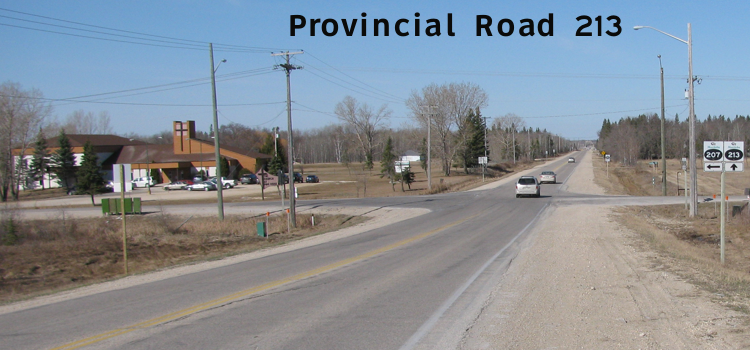
| RM of Springfield |
Westbound view near the junction of PR 207. At left is The Church at Pine Ridge. Photograph taken in April 2010. |
;) |
||
| RM of Springfield |
Westbound view near the junction of PR 207 showing a closeup of the markers. Photograph taken in April 2010. |
;) |
||
| RM of Springfield |
Eastbound view at the junction of PR 207/Deacon Road (Road 23E). Photograph taken in April 2010. |
;) |
||
| PR 213 meets PR 207 near Pine Ridge. Click here for PR 207 images. | ||||
| RM of Springfield |
Westbound view showing the first marker west of the junction of PR 207. Photograph taken in April 2010. |
;) |
||
| RM of Springfield |
Westbound view showing a closeup of the first marker west of the junction of PR 207. Photograph taken in April 2010. |
;) |
||
| RM of Springfield |
Westbound view west of the junction of PR 207. Photograph taken in April 2010. |
;) |
||
| RM of Springfield |
Westbound view west of Fairview Road. Photograph taken in April 2010. |
;) |
||
| RM of Springfield |
Westbound view approaching Lorne Hill Road (Road 22E). Photograph taken in April 2010. |
;) |
||
| RM of Springfield |
Westbound view at Lorne Hill Road (Road 22E). Photograph taken in April 2010. |
;) |
||
| RM of Springfield |
A look at the Garven Convenience store, located at the corner of Garven Road and Lorne Hill Road. Photograph taken in April 2010. |
;) |
||
| RM of Springfield |
Westbound view west of Lorne Hill Road. Photograph taken in April 2010. |
;) |
||
| RM of Springfield |
Westbound view at Waugh Road. Ahead is the sign indicating the entry into the RM of East St. Paul. Waugh Road serves as the boundary between the RM of East St. Paul and the RM of Springfield. Photograph taken in April 2010. |
;) |
||
| RM of East St. Paul |
Westbound view approaching the junction of PTH 59. Photograph taken in April 2010. |
;) |
||
| RM of East St. Paul |
Westbound view approaching the junction of PTH 59 showing a closeup of the marker. Photograph taken in April 2010. |
;) |
||
| RM of East St. Paul |
Westbound view approaching the junction of PTH 59. Photograph taken in April 2010. |
;) |
||
| RM of East St. Paul |
Westbound view at the junction of PTH 59. Photograph taken in March 2010. |
;) |
||
| RM of East St. Paul |
Westbound view at the junction of PTH 59 showing a closeup of the markers. Photograph taken in March 2010. |
;) |
||
| RM of East St. Paul |
Eastbound view at Spring Hill Drive. Photograph taken in March 2010. |
;) |
||
| PR 213 ends at PTH 59. Click here for PTH 59 images. | ||||
© Curtis Walker. All rights reserved. All pictures used on this site are the property of the respective photographers and are used by permission. No picture may be used without the consent of the respective photographer.
All pictures taken by Curtis Walker unless otherwise noted.