Provincial Trunk Highway 44
Historic Highway No. 1
| Page 1 - Lockport - PTH 9 to PR 238 | Page 2 --> |
Pictures are arranged from west to east.
| Location | Description | Photo
| ||
| RM of St. Andrews |
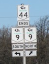
Westbound view at the junction of PTH 9. Note that the sign that indicates that Historic Highway No. 1 ends here is incorrect. Though the commemorative signage ends here, when present-day PTH 44 was PTH 1, the route turned south towards Winnipeg, where it proceeded westbound once again along Portage Avenue. In addition, the PTH 9/44 markers were replaced in the summer of 2009.  Photograph taken in April 2009. |
 |
||
| RM of St. Andrews |
Westbound view at the junction of PTH 9 showing the new markers featuring the “warthog”-style buffalo.  Photograph taken in October 2009. |
 |
||
| RM of St. Andrews |
Westbound view approaching the junction of PTH 9.  Photograph taken in June 2010. |
 |
||
| RM of St. Andrews |
Eastbound view showing the first Historic Highway No. 1 marker.  Photograph taken in April 2009. |
 |
||
| RM of St. Andrews |
Westbound view approaching the junction of PTH 9 showing a closeup of the markers.  Photograph taken in April 2009. |
 |
||
| RM of St. Andrews |
Westbound view approaching the junction of PTH 9.  Photograph taken in June 2010. |
 |
||
| RM of St. Andrews |
Eastbound view showing the first eastbound marker.  Photograph taken in April 2009. |
 |
||
| RM of St. Andrews |
Eastbound view showing the newly installed advance signage for Henderson Highway/PR 204.  Photograph taken in June 2011. |
 |
||
| RM of St. Andrews |
Westbound view approaching the junction of PTH 9.  Photograph taken in June 2010. |
 |
||
| RM of St. Andrews |
Westbound view showing the sign for Lower Fort Garry National Historic Site.  Photograph taken in April 2009. |
 |
||
| RM of St. Andrews |
Eastbound view approaching the junction of PR 238.  Photograph taken in April 2009. |
 |
||
| RM of St. Andrews |
Westbound view past the junction of PR 238.  Photograph taken in June 2010. |
 |
||
| Click here to continue east along |
||||
© Curtis Walker. All rights reserved. All pictures used on this site are the property of the respective photographers and are used by permission. No picture may be used without the consent of the respective photographer.
All pictures taken by Curtis Walker unless otherwise noted.