|
Pictures are arranged from north to south. Click here to show the route.
;)
| PR 432 ends at PTH 23 near Rosebank. Click here for PTH 23 images. | ||||
| Location | Description | Photo
| ||
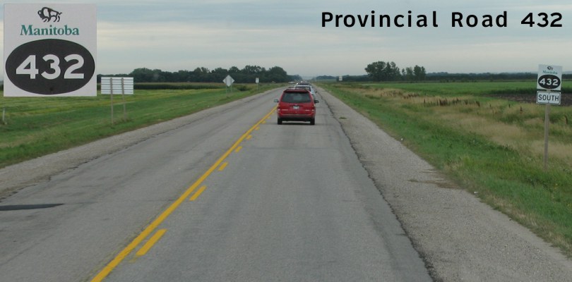
| RM of Thompson |
Southbound view showing the first southbound marker.  Photograph taken in August 2011. |
;) |
||
| RM of Thompson |
Southbound view approaching Road 24N. Photograph taken in August 2011. |
;) |
||
| RM of Thompson |
Southbound view approaching Road 23N. Photograph taken in August 2011. |
;) |
||
| RM of Thompson |
Southbound view approaching Road 22N. Photograph taken in August 2011. |
;) |
||
| RM of Thompson |
Southbound view approaching Road 21N. Photograph taken in August 2011. |
;) |
||
| RM of Thompson |
Southbound view approaching Road 19N. Photograph taken in August 2011. |
;) |
||
| RM of Thompson |
Southbound view approaching Road 18N. Photograph taken in August 2011. |
;) |
||
| RM of Thompson |
Southbound view approaching Road 18N. At right is the sign indicating the entry into the RM of Stanley. Photograph taken in August 2011. |
;) |
||
| RM of Stanley |
Southbound view approaching Road 17N. Photograph taken in August 2011. |
;) |
||
| RM of Stanley |
Southbound view approaching Road 16N. Photograph taken in August 2011. |
;) |
||
| RM of Stanley |
Southbound view approaching Road 15N. Photograph taken in August 2011. |
;) |
||
| RM of Stanley |
Southbound view approaching Road 14N. Photograph taken in August 2011. |
;) |
||
| City of Morden |
Southbound view showing the sign indicating the entry into Morden. Photograph taken in August 2011. |
;) |
||
| City of Morden |
Southbound view past Parkhill Drive. Photograph taken in August 2011. |
;) |
||
| City of Morden |
Southbound view showing the advance signage for the junction of PTH 3. Photograph taken in August 2011. |
;) |
||
| City of Morden |
Southbound view showing the advance signage for the junction of PTH 3. Photograph taken in August 2011. |
;) |
||
| City of Morden |
Southbound view showing a closeup of the advance signage for the junction of PTH 3. Photograph taken in August 2011. |
;) |
||
| City of Morden |
Southbound view approaching the junction of PTH 3. The traffic shown in this picture is due to both the parade for the annual Corn and Apple Festival, one of Manitoba's most popular summer attractions, and a Tim Hortons location one block ahead. As any Canadian can attest, a Tim Hortons location can generate a traffic jam anywhere at any time. Photograph taken in August 2011. |
;) |
||
| City of Morden |
Southbound view approaching the junction of PTH 3. Photograph taken in August 2011. |
;) |
||
| City of Morden |
Southbound view approaching the junction of PTH 3 showing a closeup of the sign giving directions to Winkler and Manitou. Photograph taken in August 2011. |
;) |
||
| City of Morden |
Southbound view approaching the junction of PTH 3. Photograph taken in August 2011. |
;) |
||
| City of Morden |
Southbound view approaching the junction of PTH 3 showing a closeup of the markers. Photograph taken in August 2011. |
;) |
||
| City of Morden |
Northbound view showing the reassurance marker north of the junction of PTH 3. Photograph taken in August 2011. |
;) |
||
| PR 432 meets PTH 3 in Morden. Click here for PTH 3 images. | ||||
| City of Morden |
Northbound view approaching the junction of PTH 3. Photograph taken in August 2011. |
;) |
||
| City of Morden |
Southbound view showing the reassurance marker south of the junction of PTH 3. Photograph taken in August 2011. |
;) |
||
| City of Morden |
Northbound view showing the sign giving directions to Rosebank, Thornhill, and Winkler. Photograph taken in August 2011. |
;) |
||
| City of Morden |
Southbound view showing the advance signage for a railway crossing with high tracks. Photograph taken in August 2011. |
;) |
||
| PR 432 ends at PR 201 south of Morden. Click here for PR 201 images. | ||||
© Curtis Walker. All rights reserved. All pictures used on this site are the property of the respective photographers and are used by permission. No picture may be used without the consent of the respective photographer.
All pictures taken by Curtis Walker unless otherwise noted.