 |
|
Pictures are arranged from north to south. Click here to show the route.
;)
| PTH 22 ends at PTH 2/PR 250 in Souris. Click here for PTH 2 images and here for PR 250 images. | ||||
| Location | Description | Photo
| ||
| Town of Souris |
Northbound view at the junction of PTH 2/PR 250.  Photograph taken in August 2010. |
;) |
||
| Town of Souris |
Northbound view near the junction of PTH 2/PR 250. Photograph taken in August 2010. |
;) |
||
| Town of Souris |
Southbound view on 1st Street showing the first southbound reassurance marker. Photograph taken in August 2010. |
;) |
||
| Town of Souris |
Southbound view on 1st Street approaching 2nd Avenue. Photograph taken in August 2010. |
;) |
||
| Town of Souris |
Northbound view on 1st Street near Frederick Avenue showing the advance signage for the junction of PTH 2/PR 250. Photograph taken in August 2010. |
;) |
||
| Town of Souris |
Southbound view on 1st Street past Frederick Avenue. Photograph taken in August 2010. |
;) |
||
| Town of Souris |
Northbound view on 1st Street passing the Souris Motor Inn. Photograph taken in August 2010. |
;) |
||
| Town of Souris |
Southbound view on 1st Street approaching Crescent Avenue. Photograph taken in August 2010. |
;) |
||
| Town of Souris |
Northbound view on 1st Street passing Crescent Avenue. Photograph taken in August 2010. |
;) |
||
| Town of Souris |
Southbound view on 1st Street approaching the turnoff to Victoria Park. Photograph taken in August 2010. |
;) |
||
| Town of Souris |
Southbound view on 1st Street at the turnoff to Victoria Park. Photograph taken in August 2010. |
;) |
||
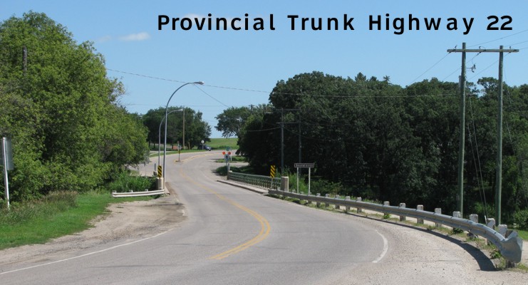
| Town of Souris |
Southbound view approaching the bridge that crosses the Souris River. Approximately 200 m north is Canada’s longest suspension bridge that crosses the same river. Photograph taken in August 2010. |
;) |
||
© Curtis Walker. All rights reserved. All pictures used on this site are the property of the respective photographers and are used by permission. No picture may be used without the consent of the respective photographer.
All pictures taken by Curtis Walker unless otherwise noted.