|
;)
Pictures are arranged from north to south.
| PTH 18 ends at PTH 2 near Wawanesa. Click here for PTH 2 images. | ||||
| Location | Description | Photo
| ||
| PTH 18 meets PTH 23 west of Ninette. Click here for PTH 23 images. | ||||
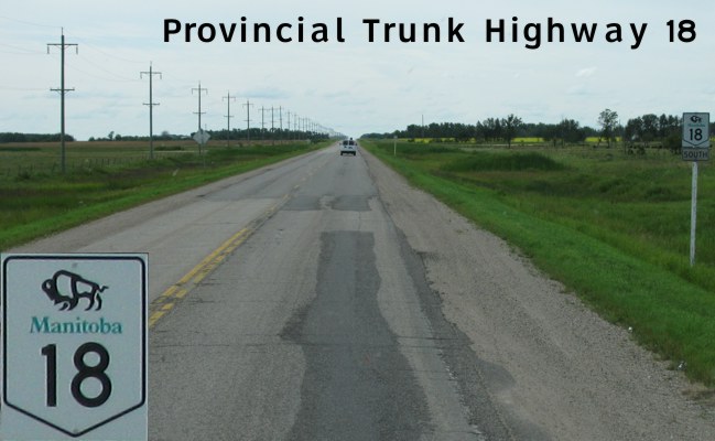
| RM of Riverside |
Southbound view past the junction of PTH 23.  Photograph taken in August 2011. |
;) |
||
| RM of Riverside |
Southbound view approaching Road 26N. At right is the sign giving the distances to Killarney as well as Rolla, ND. Photograph taken in August 2011. |
;) |
||
| RM of Riverside |
Southbound view past Road 26N. Photograph taken in August 2011. |
;) |
||
| RM of Riverside |
Southbound view approaching Road 24N. Photograph taken in August 2011. |
;) |
||
| RM of Riverside |
Southbound view approaching Road 23N. Photograph taken in August 2011. |
;) |
||
| RM of Riverside |
Southbound view approaching Road 22N. Photograph taken in August 2011. |
;) |
||
| RM of Riverside |
Southbound view approaching Road 21N. Photograph taken in August 2011. |
;) |
||
| RM of Riverside |
Southbound view approaching Road 20N. Photograph taken in August 2011. |
;) |
||
| RM of Riverside |
Southbound view approaching Road 19N. Photograph taken in August 2011. |
;) |
||
| RM of Riverside |
Southbound view approaching Road 18N. At right is the sign indicating the entry into the RM of Turtle Mountain. In 2007, the Town of Killarney and the RM of Turtle Mountain amalgamated into the RM of Killarney-Turtle Mountain, but the sign has not been changed to reflect the proper name of the municipality. Photograph taken in August 2011. |
;) |
||
| RM of Killarney-Turtle Mountain |
Southbound view showing the advance signage for the junction of PR 253. Photograph taken in August 2011. |
;) |
||
| RM of Killarney-Turtle Mountain |
Southbound view approaching the junction of PR 253. Photograph taken in August 2011. |
;) |
||
| RM of Killarney-Turtle Mountain |
Southbound view approaching the junction of PR 253. Photograph taken in August 2011. |
;) |
||
| RM of Killarney-Turtle Mountain |
Southbound view past the junction of PR 253. Photograph taken in August 2011. |
;) |
||
| RM of Killarney-Turtle Mountain |
Southbound view approaching Road 16N. Photograph taken in August 2011. |
;) |
||
| RM of Killarney-Turtle Mountain |
Southbound view approaching a crossing of the Pembina River. Photograph taken in August 2011. |
;) |
||
| RM of Killarney-Turtle Mountain |
Southbound view approaching Road 15N. Photograph taken in August 2011. |
;) |
||
| RM of Killarney-Turtle Mountain |
Southbound view approaching Road 14N. Photograph taken in August 2011. |
;) |
||
| RM of Killarney-Turtle Mountain |
Southbound view showing the 1 km advance signage for Killarney. Photograph taken in August 2011. |
;) |
||
| RM of Killarney-Turtle Mountain |
Southbound view approaching Road 13N. Photograph taken in August 2011. |
;) |
||
| RM of Killarney-Turtle Mountain |
Southbound view approaching Road 13N. Photograph taken in August 2011. |
;) |
||
| RM of Killarney-Turtle Mountain |
Southbound view approaching Geates Street. Photograph taken in August 2011. |
;) |
||
| RM of Killarney-Turtle Mountain |
Southbound view at a railway crossing. Photograph taken in August 2011. |
;) |
||
| RM of Killarney-Turtle Mountain |
Southbound view approaching Finlay Street. Photograph taken in August 2011. |
;) |
||
| RM of Killarney-Turtle Mountain |
Southbound view approaching Park Street. Photograph taken in August 2011. |
;) |
||
| RM of Killarney-Turtle Mountain |
Southbound view approaching Ellis Avenue. Photograph taken in August 2011. |
;) |
||
| RM of Killarney-Turtle Mountain |
Southbound view approaching Ellis Avenue showing the advance signage for the junction of PTH 3. Photograph taken in August 2011. |
;) |
||
| RM of Killarney-Turtle Mountain |
Southbound view approaching the junction of PTH 3. Photograph taken in August 2011. |
;) |
||
| RM of Killarney-Turtle Mountain |
Southbound view approaching the junction of PTH 3. Photograph taken in August 2011. |
;) |
||
| PTH 18 meets PTH 3 near Killarney. Click here for PTH 3 images. | ||||
© Curtis Walker. All rights reserved. All pictures used on this site are the property of the respective photographers and are used by permission. No picture may be used without the consent of the respective photographer.
All pictures taken by Curtis Walker unless otherwise noted.